*For Friday, 20 January 2006.
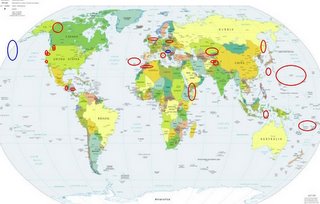
LEGEND for OVERVIEW:
Size = My surety of area for quake.
Red Circle = Probable quake to STRONG quake.
Triangle = Very Strong or Stronger quake (And usually takes extra days).
Blue Circle, etc. = Uncertainty of symptom area for probable quake.

Places to watch.
Good luck to all.
For Friday, 20 January 2006.
----------------------------------------
Possibly Serbia area (Unproven symptom - Strong)
----------------------------------------
2006/01/19 00:35:46.0 49.85 N 18.46 E ML2.0 CZECH AND SLOVAK REPUBLICS
2006/01/20 14:05:38.8 50.48 N 13.55 E 4 ML2.1 CZECH AND SLOVAK REPUBLICS
(I will watch for a repeat.)
Vanuatu to Fiji (Medium)
----------------------------------------
2006-01-19 01:26:17 5.2 12.28 S 178.76 W North of Fiji Islands
2006/01/19 05:37:33.7 15.95 S 173.94 W 80 mb5.2 TONGA ISLANDS
MAP 5.4 2006/01/20 17:51:52 -22.458 173.801 10.0 SOUTHEAST OF THE LOYALTY ISLANDS
Yukon/Northwest Territories, Canada (STRONG)
----------------------------------------
2006/01/20 18:37:35 63.11N 143.43W 5F 3.9 226 km WSW Dawson YT
Western Arabian Peninsula (12.10 N 43.80 E)
----------------------------------------
2006/01/19 12:03:30.4 14.38 N 51.17 E 15 ML4.1 EASTERN GULF OF ADEN
(Not Western)
2006/01/20 19:26:05.9 11.97 N 39.81 E 45 ML3.8 ETHIOPIA
Aleutian Trench/Pacific Seamounts area (Something weird - tingling stiffness)
----------------------------------------
map 3.8 2006/01/20 03:22:17 51.098 -178.363 1.0 ANDREANOF ISLANDS, ALEUTIAN IS., ALASKA
Azores/Madeira Islands area (STRONG)
----------------------------------------
2006/01/20 08:53:54.8 31.16 N 41.42 W 33 mb5.6 NORTHERN MID-ATLANTIC RIDGE
2006/01/20 13:29:52.4 36.88 N 9.54 W 124 mb3.0 WEST OF GIBRALTA
Willow Creek, CA (40.699 -123.783) area
----------------------------------------
(Nothing found)
Kazakhstan to Kyrgyzstan (Strong)
----------------------------------------
2006/01/20 05:42:58.3 43.83 N 79.48 E 102 Ms3.5 LAKE ISSYK-KUL, KYRGYZSTAN REG
2006/01/20 12:16:11.0 41.73 N 72.71 E ML3.1 KYRGYZSTAN
Fukutokuoka-no-ba 700 miles southeast of Tokyo to Mariana Islands) (MEDIUM)
----------------------------------------
MAP 5.1 2006/01/24 00:36:49 25.857 142.566 28.3 VOLCANO ISLANDS, JAPAN REGION
(4 extra days)
Flores, Indonesia area (Medium)
----------------------------------------
MAP 4.6 2006/01/19 05:07:11 -5.783 148.461 230.1 NEW BRITAIN REGION, PAPUA NEW GUINEA
MAP 4.9 2006/01/19 05:06:56 -4.287 148.595 35.0 BISMARCK SEA
MAP 5.1 2006/01/20 07:01:02 0.084 124.227 142.0 MINAHASA, SULAWESI, INDONESIA
2006/01/21 09:34:55.7 8.68 S 122.44 E 100 mb5.3 FLORES, INDONESIA, REGION
Sakhalin to Southeastern Russia (Medium)
----------------------------------------
2006/01/18 11:10:53.8 49.22 N 152.04 E 250 mb4.6 NW. KURIL ISLANDS, RUSSIA
(2 days early - deep)
Mt. St. Helen's then Seattle area (MEDIUM for both areas)
----------------------------------------
map 2.7 2006/01/21 09:59:13 46.200 -122.196 0.0 1 km ( 1 mi) W of Mount St. Helens Volcano, WA
Poland/Germany (Medium)
----------------------------------------
2006/01/19 03:10:28.6 51.55 N 16.14 E ML2.4 POLAND
2006/01/20 23:21:23.2 51.33 N 16.18 E ML2.2 POLAND
Guatamala/El Salvador area then Nicaragua (Medium for Guatamala)
----------------------------------------
06/01/21 14:29:41 13.04N 87.38W 60.3 2.9ML Nicaragua
06/01/21 11:40:07 12.03N 86.56W 145.5 2.9ML Oeste-Suroeste de Managua
06/01/20 10:44:06 12.05N 87.16W 54.5 2.7ML Frente a Poneloya
06/01/20 08:58:36 11.80N 87.73W 53.5 3.5ML Frente a Corinto
06/01/20 07:26:05 12.25N 87.36W 58.4 2.3ML Frente a Corinto
06/01/20 05:59:48 11.50N 86.82W 47.9 2.6ML Frente a Masachapa
06/01/20 04:53:30 10.60N 86.18W 8.2 2.3ML Oceano Pacífico de Nicaragua
06/01/19 22:42:42 11.67N 87.88W 59.6 3.2ML Oceano Pacífico de Nicaragua
06/01/19 18:44:22 12.02N 88.91W 95.3 3.9ML Frente a El Salvador
Parkfield area
----------------------------------------
map 1.5 2006/01/22 00:07:41 36.007 -120.582 4.2 18 km ( 11 mi) NW of Parkfield, CA
Afghanistan/Tajikistan
----------------------------------------
2006/01/20 19:36:50.5 38.57 N 73.11 E 150 mb4.6 TAJIKISTAN-XINJIANG BORDER REG
Hindu Kush/Pakistan
----------------------------------------
2006/01/21 11:13:22.0 36.49 N 69.58 E 151 mb4.2 HINDU KUSH, AFGHANISTAN, REG
Kyushu/Ryukyu, Japan (I keep getting symptoms for this known area - but nothing is ever on the lists. Don't know why. I just post what I get symptoms for.)
----------------------------------------
MAP 4.2 2006/01/20 17:19:25 30.122 130.492 10.0 KYUSHU, JAPAN
England to Viking Graben
----------------------------------------
HUMBER
Origin time Lat Lon Azres Timres Wres Nphase Ntot Nsta Netmag
2006-019:21.39.22.0 53.60 1.49 11.52 3.99 6.87 3 3 3 2.97
Central to Southern Italy
----------------------------------------
2006/01/20 14:20:00.0 37.71 N 14.51 E 2 ML2.7 SICILY, ITALY
2006/01/20 21:27:00.0 38.44 N 15.42 E 164 ML2.9 SICILY, ITALY
Morocco/Algeria area
----------------------------------------
2006/01/19 17:49:35.6 36.87 N 3.85 E mb3.7 NORTHERN ALGERIA
Petrolia (Medium)
----------------------------------------
(Nothing found)
Peace to all.

