*For Thursday, 23 February 2006.
LEGEND for OVERVIEW:
Size = My surety of area for quake.
Red Circle = Probable quake to STRONG quake.
Triangle = Very Strong or Stronger quake (And usually takes extra days).
Blue Circle, etc. = Uncertainty of symptom area for probable quake.
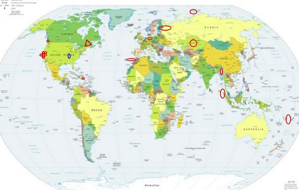
Places to watch.
Good luck to all.
For Thursday, 23 February 2006.
----------------------------------------
Myanmar (25.09 N 96.07 E) (Possibly 4 magnitude - felt 4 distinct bubbles)
----------------------------------------
2006-02-23 20:07:27.8 26.73N 91.56E 33 mb5.3 NORTHEASTERN INDIA
2006-02-23 20:04:57.8 27.36N 91.53E 33 mb5.6 BHUTAN
Germany (49.40N 7.00E) (Medium)
----------------------------------------
2006-02-23 12:32:25.1 49.35N 6.98E ML3.0 GERMANY
The Geysers (MEDIUM)
----------------------------------------
MAP 1.4 2006/02/22 09:21:58 38.826 -122.799 4.1 3 km ( 2 mi) NNE of The Geysers, CA
MAP 2.1 2006/02/22 15:46:53 38.814 -122.807 0.0 2 km ( 1 mi) N of The Geysers, CA
MAP 1.9 2006/02/23 09:11:46 38.817 -122.817 3.3 2 km ( 1 mi) NNW of The Geysers, CA
MAP 1.5 2006/02/23 14:31:57 38.826 -122.751 0.0 3 km ( 2 mi) WSW of Cobb, CA
MAP 1.9 2006/02/23 14:29:54 38.834 -122.758 0.7 3 km ( 2 mi) W of Cobb, CA
MAP 3.2 2006/02/23 15:10:39 38.827 -122.804 4.5 3 km ( 2 mi) N of The Geysers, CA
MAP 2.1 2006/02/23 17:58:18 38.822 -122.810 3.9 3 km ( 2 mi) N of The Geysers, CA
MAP 1.8 2006/02/23 19:34:07 38.818 -122.807 4.5 2 km ( 1 mi) N of The Geysers, CA
Northern Sumatra (1.75N 97.29E)
----------------------------------------
(Nothing found)
Fiji Region (5.3 17.53S 177.54W)
----------------------------------------
2006-02-23 22:36:49 5.5 25.10 S 179.66 W South of Fiji Islands
Parkfield Fault
----------------------------------------
(Nothing found)
Finland/Northeast Russia (Indication of deep quake)
----------------------------------------
(Nothing found)
Strait of Gibraltar/Madeira Islands area
----------------------------------------
2006-02-23 00:01:15.0 38.67N 28.58W ML2.8 AZORES ISLANDS, PORTUGAL
2006-02-23 01:33:07.2 32.39N 5.97W 20 M3.0 MOROCCO
2006-02-23 07:04:00.6 35.12N 3.62W 15 mb2.8 STRAIT OF GIBRALTAR
Kazakhstan (51.99 N 70.86 E) (Strong)
----------------------------------------
2006-02-22 07:52:46.0 53.83N 75.36E ML4.1 EASTERN KAZAKHSTAN
Vancouver Island area
----------------------------------------
2006/02/23 17:52:19 49.29N 127.59W 10F 1.0 117 km WSW Gold R. BC
Severnaya Zemlya area
----------------------------------------
(Nothing found)
The New Madrid Fault (Possibly Missouri/Illinois border - STRONG)
----------------------------------------
(Nothing found)
Lake Tahoe area (Indication of deep quake - strong)
----------------------------------------
MAP 2.6 2006/02/24 23:57:02 40.229 -121.171 3.1 1 km ( 1 mi) NNE of Almanor, CA
MAP 3.2 2006/02/24 23:54:47 40.230 -121.176 0.0 2 km ( 1 mi) N of Almanor, CA
(Not deep)
Ludlow/Yucca Valley, California area
----------------------------------------
MAP 1.2 2006/02/22 10:05:38 34.013 -116.438 10.2 9 km ( 5 mi) NE of Desert Hot Springs, CA
MAP 1.4 2006/02/22 22:09:52 34.267 -116.865 7.4 2 km ( 1 mi) WNW of Big Bear City, CA
MAP 1.5 2006/02/23 18:43:43 34.585 -116.279 11.0 19 km ( 12 mi) SW of Ludlow, CA
MAP 1.5 2006/02/23 18:58:03 34.919 -116.942 26.0 10 km ( 6 mi) ENE of Barstow, CA
MAP 1.5 2006/02/23 20:06:47 34.305 -116.448 7.5 20 km ( 13 mi) N of Yucca Valley, CA
MAP 1.3 2006/02/23 23:47:33 34.228 -116.739 6.9 10 km ( 6 mi) ESE of Big Bear City, CA
CHARLEVOIX SEISMIC ZONE, QUE and North of (47.57N 69.89W) (Very Strong)
http://www.seismo.nrcan.gc.ca/eqmaps/charlevoix_e.php>Quebec

----------------------------------------
2006/02/25 02:02:41 45.67N 75.21W 18.0g 1.8MN GSC 8 km N from Thurso, QC. Aftershock. Felt
2006/02/25 01:39:22 45.66N 75.23W 18.0g 4.5MN GSC 7 km N from Thurso, QC. Felt.
(2 extra days...unless there is more coming. Could be as late as 1 March.)
http://kennebecjournal.mainetoday.com/news/local/2468851.shtml
Friday, February 24, 2006
Somerset rumbles, but why?
By DARLA L. PICKETT
Staff Writer
Copyright © 2006 Blethen Maine Newspapers Inc.
Somerset County boom a mystery
SKOWHEGAN -- The earth shook and buildings rumbled Thursday morning, according to at least a dozen residents who reported tremors in Anson, Madison, Skowhegan and Norridgewock.
Shortly before 10 a.m., the Somerset County Communications Center was inundated with calls from people who said they had experienced earthquake-type movement.
Despite numerous reports within the 15-mile radius, local and state authorities could find no documented account that any type of earthquake or tremor had occurred.
State geologist Bob Marvinney of the Maine Geological Service said that if an earthquake had occurred, it was not recorded in Maine or New England.
Marvinney said he had contacted the New England Seismic Network, and authorities there said nothing was apparent: "I'm surprised we didn't pick up anything. There are other kinds of explanations like quarrywork and roadwork," he said.
An official at the National Weather Service said he also had heard no reports.
Emergency Management Director Robert Higgins Sr. said he is going to ask officials to look again.
"I'd like them to relook at what they may have; this is the second occurrence in less than a week of such magnitude," he said.
Higgins said residents of Solon and South Solon last Friday reported what sounded like a loud explosion, during which houses and mobile homes shook: "That would indicate a tremor," he said.
Residents who reported the shaking Thursday said the tremors were strong.
Norridgewock's town manager, John Doucette, said the shaking and noise was so significant, it sounded like a Dumpster had fallen off a truck or a truck had hit the building: "We went outside to see if there was an accident."
More than a mile away, Jeffrey McGown, district manager of Waste Management on U.S. Route 2 in Norridgewock, said he was sitting in his office when the noise and shaking occurred.
"It felt like somebody with a delivery type of vehicle had backed into our building," McGown said. "I was on a conference call and I got up to see what had struck. We went out on the site and looked around, we thought maybe the town airport had an experience. It was so localized, we thought a delivery truck had hit the front porch."
In Anson, about six miles away, the shaking was so strong, even off-duty dispatcher William Crawford called the Communications Center.
"I heard a loud boom that shook the house," Crawford said. "At first I thought it was the furnace. I asked my son, 'Did you feel that?' "It shook the couch. I thought maybe something fell upstairs, or maybe the chimney collapsed or something. I went outside to look around. You can see the town garage from the house; I thought maybe it was the back of the bucket banging."
Late Thursday, Higgins said he checked with Guilford Industries to see if they were working the quarry in the Embden-Solon area: "They said they hadn't done any blasting since last fall. And it was no sonic boom -- not that loud and shaking that many buildings. It's just unexplainable, I guess."
Darla L. Pickett -- 474-9534, Ext. 341
dpickett@centralmaine.com
Puerto Rico
----------------------------------------
MAP 3.4 2006/02/23 01:17:37 18.927 -65.109 29.6 67 km ( 42 mi) NNW of CHARLOTTE AMALIE, US Virgin Islands
MAP 2.8 2006/02/23 02:58:49 18.614 -66.724 11.2 16 km ( 10 mi) NNE of Carrizales, PR
MAP 2.8 2006/02/23 15:05:39 19.137 -66.515 20.8 75 km ( 47 mi) N of Tierras Nuevas Poniente, PR
Coso Junction (35.962 -117.659)
----------------------------------------
MAP 1.9 2006/02/22 06:16:10 36.026 -117.770 3.4 16 km ( 10 mi) E of Coso Junction, CA
MAP 2.0 2006/02/22 17:55:29 36.021 -117.765 2.6 17 km ( 10 mi) E of Coso Junction, CA
MAP 1.2 2006/02/23 05:50:58 35.622 -117.588 7.8 8 km ( 5 mi) E of Ridgecrest, CA
Lake Nacimiento (35.643 -120.832)
----------------------------------------
(Nothing found)
Peace to all.

posted by Unknown @ 2:09 PM
0 comments
![]()
![]()
