*For Tuesday, 23 May 2006.
LEGEND for OVERVIEW: Size = My surety of area for quake.
Red Circle = Probable quake to STRONG quake.
Triangle = Very Strong or Stronger quake (And usually takes extra days).
Blue Circle, etc. = Uncertainty of symptom area for probable quake.
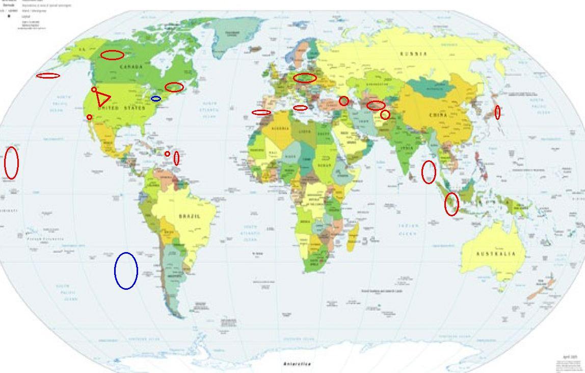
Places to watch.
Good luck to all.
For Tuesday, 23 May 2006.
----------------------------------------
Mt. St. Helen’s (Still consider this STRONG - right neck symptom only hurts when provoked by turning head.)
----------------------------------------
MAP 1.6 2006/05/23 02:18:54 46.195 -122.195 0.0 1 km ( 1 mi) WSW of Mount St. Helens Volcano, WA
MAP 1.4 2006/05/23 15:04:36 46.195 -122.193 0.6 1 km ( 1 mi) WSW of Mount St. Helens Volcano, WA
MAP 1.1 2006/05/23 17:53:19 46.194 -122.195 0.0 1 km ( 1 mi) WSW of Mount St. Helens Volcano, WA
MAP 1.7 2006/05/23 21:35:36 46.194 -122.197 0.0 1 km ( 1 mi) WSW of Mount St. Helens Volcano, WA
Northern Sumatra/Andaman Islands area (11.12 N 94.76 E) then Southern Sumatra (Strong for Andaman area)
----------------------------------------
22May2006 10:09:52.1 13.2N 92.6E 33 mb=5.0 M GSR ANDAMAN ISLANDS, INDIA
2006-05-22 19:16:33.0 1.82 N 99.72 E 200 mb 4.9 NORTHERN SUMATERA, INDONESIA
Poland/Germany
----------------------------------------
2006-05-23 11:55:27.9 51.13 N 15.72 E 20 ML 2.7 POLAND
2006-05-23 16:11:56.9 50.88 N 16.16 E 8 ML 2.3 POLAND
2006-05-23 21:07:13.3 51.20 N 15.96 E 10 ML 2.6 POLAND
Sicily, Italy/Ionian Sea (MEDIUM)
----------------------------------------
2006-05-23 08:42:24.0 39.35 N 16.29 E 4 ML 2.6 SOUTHERN ITALY
Aleutian Islands Center area (52.160 -173.949) (2 different symptoms - Strong)
----------------------------------------
2.9 2006/05/23 11:08:20 50.984 -177.094 35.0 ANDREANOF ISLANDS, ALEUTIAN IS., ALASKA
MAP 2.7 2006/05/23 09:31:45 52.804 -167.394 1.0 FOX ISLANDS, ALEUTIAN ISLANDS, ALASKA
MAP 4.4 2006/05/23 15:40:52 51.716 179.571 50.0 RAT ISLANDS, ALEUTIAN ISLANDS, ALASKA
Utah/Wyoming/Idaho area (EXTREMELY STRONG)
http://homepage.mac.com/venitar/Utah/Utah2.html>Venitar
----------------------------------------
MAP 1.2 2006/05/23 01:24:09 39.724 -110.747 1.1 10 km ( 6 mi) ENE of Helper, UT
MAP 1.1 2006/05/23 05:25:02 44.789 -110.976 6.5 17 km ( 11 mi) NE of West Yellowstone, MT
MAP 1.8 2006/05/23 17:34:41 41.143 -112.880 1.1 64 km ( 40 mi) W of Hooper, UT
MAP 1.3 2006/05/24 23:08:18 44.261 -110.643 8.7 56 km ( 35 mi) ENE of Warm River, ID
MAP 1.6 2006/05/24 22:08:56 41.352 -112.008 1.8 3 km ( 2 mi) E of South Willard, UT
MAP 2.1 2006/05/24 20:19:48 39.298 -112.114 0.4 6 km ( 4 mi) N of Scipio, UT
MAP 1.5 2006/05/24 18:15:38 40.457 -111.335 2.0 6 km ( 4 mi) ESE of Daniel, UT
MAP 1.1 2006/05/24 14:00:02 39.704 -110.726 0.7 11 km ( 7 mi) E of Helper, UT
MAP 1.7 2006/05/24 07:11:00 39.457 -111.216 5.2 23 km ( 14 mi) ESE of Mount Pleasant, UT
MAP 1.5 2006/05/24 03:20:49 39.456 -111.206 4.8 24 km ( 15 mi) ESE of Mount Pleasant, UT
MAP 1.5 2006/05/24 03:18:57 39.607 -110.390 0.8 6 km ( 4 mi) N of Sunnyside, UT
MAP 1.7 2006/05/24 03:05:09 37.477 -112.404 7.7 8 km ( 5 mi) ENE of Alton, UT
Obsidian Butte, California area (33.189°N, 115.613°W)
----------------------------------------
MAP 2.3 2006/05/22 19:57:47 32.514 -115.189 0.1 26 km ( 16 mi) NNW of Guadalupe Victoria, Mexico
MAP 2.2 2006/05/24 10:44:08 32.270 -115.193 6.0 8 km ( 5 mi) WSW of Guadalupe Victoria, Mexico
MAP 3.1 2006/05/24 09:58:49 32.363 -115.254 6.0 16 km ( 10 mi) WNW of Guadalupe Victoria, Mexico
MAP 2.2 2006/05/24 09:32:16 32.401 -115.180 6.0 14 km ( 9 mi) NNW of Guadalupe Victoria, Mexico
MAP 2.3 2006/05/24 07:31:09 32.342 -115.239 6.0 13 km ( 8 mi) WNW of Guadalupe Victoria, Mexico
MAP 2.4 2006/05/24 06:57:13 32.183 -115.185 7.2 14 km ( 9 mi) SSW of Guadalupe Victoria, Mexico
MAP 2.3 2006/05/24 06:29:41 32.283 -115.212 42.2 10 km ( 6 mi) W of Guadalupe Victoria, Mexico
MAP 2.1 2006/05/24 06:14:44 32.347 -115.240 21.8 14 km ( 9 mi) WNW of Guadalupe Victoria, Mexico
MAP 2.6 2006/05/24 05:14:27 32.308 -115.208 30.9 9 km ( 6 mi) WNW of Guadalupe Victoria, Mexico
MAP 2.5 2006/05/24 05:05:10 32.349 -115.176 36.3 9 km ( 6 mi) NW of Guadalupe Victoria, Mexico
MAP 2.5 2006/05/24 05:01:36 32.294 -115.182 35.0 7 km ( 4 mi) W of Guadalupe Victoria, Mexico
MAP 3.4 2006/05/24 04:49:57 32.256 -115.212 53.0 10 km ( 6 mi) WSW of Guadalupe Victoria, Mexico
MAP 1.7 2006/05/24 04:44:22 33.324 -115.728 6.1 3 km ( 2 mi) S of Bombay Beach, CA
MAP 2.9 2006/05/24 04:39:34 32.333 -115.180 13.0 8 km ( 5 mi) NW of Guadalupe Victoria, Mexico
MAP 3.2 2006/05/24 04:36:54 32.203 -115.191 20.7 12 km ( 8 mi) SW of Guadalupe Victoria, Mexico
MAP 5.0 2006/05/24 04:20:27 32.347 -115.189 5.0 10 km ( 6 mi) NW of Guadalupe Victoria, Mexico
MAP 3.9 2006/05/24 04:19:06 32.366 -115.264 0.9 17 km ( 10 mi) WNW of Guadalupe Victoria, Mexico
IRAN-ARMENIA-AZERBAIJAN BDR REG (39.35N 44.59E) (2 different symptoms - Strong)
----------------------------------------
2006-05-22 11:25:20.0 42.33 N 49.66 E ML 3.2 CASPIAN SEA
2006-05-23 03:53:46.5 32.52 N 48.81 E 17 M 3.2 WESTERN IRAN
2006-05-23 19:37:05.8 39.67 N 48.75 E 18 M 3.4 IRAN-ARMENIA-AZERBAIJAN BDR REG
2006-05-24 03:17:19.3 41.08 N 44.11 E 1 ML 3.7 WESTERN CAUCASUS
2006-05-25 08:04:02.6 39.54 N 48.08 E 30 ML 3.7 IRAN-ARMENIA-AZERBAIJAN BDR REG
2006-05-25 10:15:02.5 40.14 N 43.56 E ML 2.8 TURKEY-GEORGIA-ARMENIA BRD REG
(2 extra days)
2006-05-26 14:59:37.3 38.23 N 45.32 E 40 mb 4.5 IRAN-ARMENIA-AZERBAIJAN BDR REG
(3 extra days)
Honshu, Japan and North of
----------------------------------------
2006-05-26 10:25:58.2 30.56 N 138.24 E 424 mb 5.0 SOUTHEAST OF HONSHU, JAPAN
(3 extra days)
Afghanistan (34.0N 69.6E) then Turkmenistan/Uzbekistan area
----------------------------------------
23May2006 02:40:32.1 27.7S 71.2W 33 MS=4.2 M*GSR NEAR COAST OF NORTHERN CHI
Yukon/Northwest Territories (Indication of depth - Strong)
----------------------------------------
(Nothing found)
CHARLEVOIX SEISMIC ZONE, QUE. (47.75N 69.73W) (STRONG)
----------------------------------------
MAP 2.8 2006/05/23 04:05:24 46.149 -74.987 10.0 78 km ( 48 mi) NNE of Cumberland, Canada
2006/05/22 20:20:24 47.72N 70.04W 12.8 1.5MN GSC CHARLEVOIX SEISMIC ZONE, QUE.
Puerto Rico (18.399N 67.262W) then Virgin Islands (STRONG for both areas)
----------------------------------------
MAP 3.0 2006/05/23 00:03:57 18.053 -66.155 16.8 6 km ( 3 mi) ENE of La Plena, PR
MAP 3.0 2006/05/23 16:28:14 18.919 -65.177 13.9 68 km ( 42 mi) NNW of CHARLOTTE AMALIE, US Virgin Islands
MAP 4.0 2006/05/24 16:38:55 18.181 -65.900 147.6 3 km ( 2 mi) W of Las Piedras, PR
Possibly West Chile Rise (-40.320 -91.941) (New symptom guesstimate)
----------------------------------------
2006-05-23 02:40:31.6 26.72 S 71.08 W 30 f mb 4.9 OFF COAST OF NORTHERN CHILE
2006-05-24 00:32:35 5.3 27.45 S 112.70 W Easter Island Region
2006-05-24 06:23:25.5 31.81 S 111.91 W 10 G M 4.8 EASTER ISLAND REGION
2006-05-25 20:48:04 5.6 18.19 S 71.08 W Off Coast of Northern Chile
(2 extra days and all quakes are off some in location from expected area but it WAS a guesstimate.)
Strait of Giraltar area
----------------------------------------
2006-05-21 03:24:37.0 36.50 N 7.18 W 27 ML 2.0 STRAIT OF GIBRALTAR
(2 days early)
2006-05-22 03:28:55.0 36.70 N 4.52 W 31 ML 3.0 STRAIT OF GIBRALTAR
Hawaii and South of
----------------------------------------
MAP 2.2 2006/05/23 03:30:37 19.737 -155.850 37.8 16 km ( 10 mi) E of Kalaoa, HI
MAP 2.9 2006/05/23 03:27:46 19.386 -155.243 3.6 7 km ( 4 mi) S of Volcano, HI
MAP 2.3 2006/05/23 05:04:53 19.385 -155.248 3.2 7 km ( 5 mi) S of Volcano, HI
MAP 1.8 2006/05/23 06:20:53 19.386 -155.235 6.7 7 km ( 4 mi) S of Volcano, HI
MAP 1.8 2006/05/23 06:55:10 19.392 -155.282 3.1 8 km ( 5 mi) SW of Volcano, HI
MAP 2.9 2006/05/23 09:14:24 19.981 -155.283 13.7 5 km ( 3 mi) W of Laupahoehoe, HI
MAP 1.8 2006/05/23 13:10:39 19.334 -155.134 5.8 15 km ( 10 mi) S of Fern Forest, HI
MAP 2.0 2006/05/23 13:10:26 19.336 -155.135 3.4 15 km ( 9 mi) S of Fern Forest, HI
MAP 2.2 2006/05/23 14:26:28 19.237 -155.591 7.2 12 km ( 8 mi) WNW of Pahala, HI
MAP 1.8 2006/05/23 18:27:09 19.407 -155.275 1.8 6 km ( 4 mi) SW of Volcano, HI
MAP 1.9 2006/05/23 18:26:12 19.409 -155.268 0.7 6 km ( 4 mi) SW of Volcano, HI
MAP 1.9 2006/05/23 18:30:19 19.222 -155.255 7.0 24 km ( 15 mi) E of Pahala, HI
MAP 1.7 2006/05/23 20:07:55 19.626 -155.413 24.7 27 km ( 17 mi) NW of Volcano, HI
MAP 1.9 2006/05/23 20:54:01 19.381 -155.239 0.0 8 km ( 5 mi) S of Volcano, HI
MAP 1.9 2006/05/23 23:31:12 19.413 -155.324 5.9 10 km ( 6 mi) WSW of Volcano, HI
Possibly South Shore Lake Erie (41.87N 80.87W)
----------------------------------------
2006/05/21 14:15:28 41.81N 81.43W 5.0g 2.2MN GSC South shore Lake Erie
(2 days early)
Peace to all.

posted by Unknown @ 3:14 PM
0 comments
![]()
![]()
