*For Wednesday, 21 June 2006.
LEGEND for OVERVIEW: Size = My surety of area for quake.
Red Circle = Probable quake to STRONG quake.
Triangle = Very Strong/Stronger quake (Usually takes extra days).
Blue Circle, etc. = Uncertainty of symptom area for probable quake.
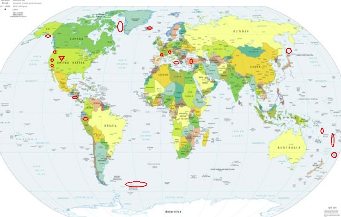
Places to watch.
Good luck to all.
For Wednesday, 21 June 2006.
----------------------------------------
Coast of El Salvador (13.30N 88.79W)
(2 different symptoms - STRONG)
----------------------------------------
06/06/21 23:58:17 12.36N 87.66W 115.6 0.0 Frente al Cosigüina
06/06/21 23:03:59 12.11N 87.17W 41.0 2.0ML Frente a Poneloya
06/06/21 21:11:40 12.14N 87.30W 44.1 2.4ML Frente a Poneloya
06/06/21 19:13:15 11.94N 89.07W 12.3 3.4ML Frente a El Salvador
06/06/21 18:29:00 12.43N 88.01W 18.2 2.9ML Frente al Cosigüina
06/06/21 15:08:06 11.95N 87.03W 56.8 2.7ML Frente a Puerto Sandino
06/06/21 10:30:10 12.15N 87.76W 1.0 3.3MC Frente al Cosigüina
06/06/21 06:45:38 12.17N 87.58W 15.0 2.6MC Frente a Corinto
06/06/21 03:01:39 12.36N 87.58W 24.3 3.4ML Frente al Cosigüina
06/06/21 01:19:09 11.26N 87.35W 15.0 3.8MC Frente a Masachapa
06/06/20 23:01:59 11.67N 86.88W 16.1 2.4ML Frente a Masachapa
06/06/20 22:01:11 14.08N 91.88W 18.9 4.4ML Frente a Guatemala
06/06/20 19:08:36 12.04N 87.82W 16.7 3.2ML Oceano Pacífico de Nicaragua
Kermadec Islands area
----------------------------------------
20Jun2006 04:20:46.2 30.0S 178.4W100 mb=4.8 M GSR KERMADEC ISLANDS, NEW ZEAL0651
South Sandwich Islands area
----------------------------------------
2006-06-23 05:40:31 5.6 55.38S 29.35W South Sandwich Islands Region
(2 extra days - also posted on the 25th for the cluster of Mid-Atlantic Ridge quakes.)
Coso Junction (36.027 -117.886) (Strong)
----------------------------------------
1.1 2006/06/21 03:22:25 35.798 -117.965 13.7 22 km ( 13 mi) NW of Inyokern, CA
1.4 2006/06/21 09:18:01 36.056 -117.855 3.5 8 km(5 mi) E of Coso Junction, CA
1.6 2006/06/21 10:38:32 36.066 -117.847 3.2 9 km(6 mi) ENE of Coso Junction, CA
1.1 2006/06/21 12:19:52 36.024 -117.889 5.0 6 km(4 mi) ESE of Coso Junction, CA
2.0 2006/06/21 15:54:10 36.012 -117.802 1.9 14 km(8 mi) ESE of Coso Junction, CA
Iceland (Possibly volcanic - Strong)
----------------------------------------
2006-06-22 22:21:56 4.6 53.94N 32.94W Reykjanes Ridge
South of Alaska (Indication of depth)
----------------------------------------
3.6 2006/06/20 01:36:13 53.657 -160.026 10.0 SOUTH OF ALASKA
3.9 2006/06/20 02:52:38 59.139 -145.990 15.0 GULF OF ALASKA
3.5 2006/06/21 04:57:07 56.835 -148.081 1.0 GULF OF ALASKA
Sicily, Italy/Ionian Sea
----------------------------------------
2006-06-21 07:17:49.0 37.82N 14.86E 20 ML 3.1 SICILY, ITALY
2006-06-21 14:59:25.8 40.16N 19.59E 2 ML 3.8 ALBANIA
Northern Peru
----------------------------------------
21Jun2006 12:40:54.4 2.3S 77.3W170 mb=5.1 M*GSR PERU-ECUADOR BORDER REGION
Mt. St. Helen’s
----------------------------------------
1.7 2006/06/21 06:12:11 46.194 -122.198 0.8 1 km(1 mi) WSW of Mount St. Helens Volcano, WA
2.8 2006/06/21 13:45:38 46.204 -122.170 0.0 1 km(1 mi) ENE of Mount St. Helens Volcano, WA
1.2 2006/06/21 16:04:31 46.194 -122.197 0.4 1 km(1 mi) WSW of Mount St. Helens Volcano, WA
Switzerland (47.9N 8.4E)
----------------------------------------
2006-06-19 01:28:05.7 46.80N 8.70E 2 ML2.1 SWITZERLAND
2006-06-19 05:17:18.1 44.22N 10.76E 2 ML2.8 NORTHERN ITALY
(2 days early)
2006-06-22 16:06:25.9 46.28N 7.30E ML2.8 SWITZERLAND
Fiji and South of (15.5S 176.1E)
----------------------------------------
2006-06-23 00:27:22 5.3 17.82S 178.55W Fiji Islands Region
Greenland Coast (69.47N 53.43W) to Baffin Bay
(MEDIUM)
----------------------------------------
GREENLAND SEA
Origin time Lat Lon Azres Timres Wres Nphase Ntot Nsta Netmag
2006-172:01.34.14.0 78.67 -1.09 13.05 0.31 3.57 2 3 3 2.52
GREENLAND SEA
Origin time Lat Lon Azres Timres Wres Nphase Ntot Nsta Netmag
2006-172:08.33.03.0 73.05 -10.62 17.00 0.09 4.34 2 2 1 2.25
(This is the wrong side of Greenland that I thought would quake.)
France area (47.60N 1.18W)
----------------------------------------
2006-06-21 09:53:38.5 47.02N 0.35E 10 ML 2.6 FRANCE
2006-06-21 19:53:42.2 45.78N 6.65E 8 ML 2.7 FRANCE
Almanor, California (40.230 -121.176)
----------------------------------------
(Nothing found)
Turkey
----------------------------------------
2006-06-21 00:21:38.4 39.92N 39.71E 13 MD2.7 TURKEY
2006-06-21 02:56:20.5 37.36N 35.86E 24 MD2.8 TURKEY
2006-06-21 02:02:46.1 39.56N 27.44E 22 MD2.8 TURKEY
2006-06-21 06:34:40.2 39.58N 28.75E 24 MD2.8 TURKEY
2006-06-21 09:03:04.3 37.26N 27.89E 24 MD2.7 TURKEY
2006-06-21 12:50:08.8 37.78N 29.18E 17 MD3.0 TURKEY
2006-06-21 18:17:28.8 37.70N 43.40E 21 MD3.0 TURKEY
Santa Cruz Islands (12.88S 166.61E) (MEDIUM)
----------------------------------------
(Nothing found)
Southern Sea of Okhotsk/Sakhalin
----------------------------------------
2006-06-22 06:05:03.9 48.09N 147.32E 430 mb4.3 SEA OF OKHOTSK
2006-06-24 04:34:49 4.8 48.13N 143.30E Sakhalin, Russia
(3 extra days)
Utah (Very Strong)
http://equineestates.com/library/United_States/utah.htm>equineestates

----------------------------------------
2.5 2006/06/20 01:53:26 40.946 -112.888 8.7 UTAH
1.7 2006/06/21 00:23:42 39.462 -111.197 6.4 24 km(15 mi) ESE of Mount Pleasant, UT
1.9 2006/06/21 05:04:39 39.611 -110.391 1.0 7 km(4 mi) N of Sunnyside, UT
Peace to all.

posted by Unknown @ 2:47 PM
0 comments
![]()
![]()
