*For Monday, 11 September 2006.
LEGEND for OVERVIEW: Size = My surety of area for quake.
Red Circle = Probable quake to STRONG quake.
Triangle = Very Strong/Stronger quake (Usually takes extra days).
Blue Circle, etc. = Uncertainty of symptom area for probable quake.
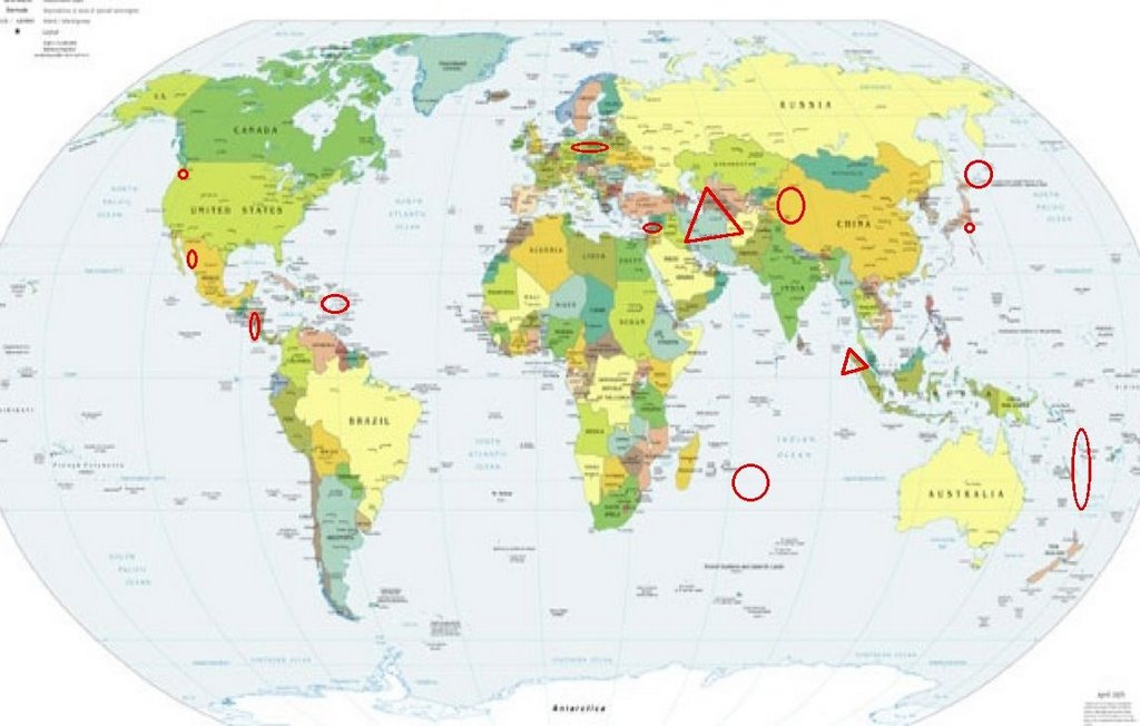
Places to watch.
Good luck to all.
For Monday, 11 September 2006.
---------------------------------------
Puerto Rico/Virgin Islands (STRONG)
---------------------------------------
3.3 2006/09/12 23:08:22 19.143N -68.773W 2.6 50 km (31 mi) NE of El Seybo, El Seybo, Dominican Republic
2.9 2006/09/12 22:56:22 19.029N -67.277W 12.2 62 km (39 mi) NNW of San Antonio, PR
3.5 2006/09/12 19:16:54 18.497N -68.100W 145.6 66 km (41 mi) ESE of Higüey, La Altagracia, Dominican Republic
1.8 2006/09/12 19:11:29 17.965N -66.811W 7.1 3 km ( 2 mi) S of Indios, PR
2.2 2006/09/12 10:08:53 18.255N -66.188W 14.0 6 km ( 3 mi) NE of Comerío, PR
2.1 2006/09/12 08:49:24 18.031N -66.433W 13.6 2 km ( 1 mi) NW of Las Ollas, PR
2.0 2006/09/12 07:30:08 17.838N -66.673W 13.6 18 km (11 mi) SSE of Tallaboa, PR
1.9 2006/09/12 03:17:32 18.076N -66.963W 11.3 1 km ( 0 mi) SE of Sabana Grande, PR
2.3 2006/09/12 02:55:14 18.034N -66.438W 12.3 3 km ( 2 mi) NW of Las Ollas, PR
3.3 2006/09/12 01:09:21 18.683N -64.603W 38.8 25 km (16 mi) N of East End-Long Look, Tortola, British Virgin Islands
2.3 2006/09/11 22:12:31 17.826N -67.026W 40.1 17 km (10 mi) S of La Parguera, PR
2.6 2006/09/11 18:32:57 18.910N -66.615W 39.0 51 km (32 mi) NNE of Carrizales, PR
3.1 2006/09/11 00:48:03 19.248N -66.573W 34.7 88 km (55 mi) N of Tierras Nuevas Poniente, PR
3.3 2006/09/11 00:41:39 19.200N -66.588W 25.3 83 km (51 mi) NNE of Carrizales, PR
3.0 2006/09/10 20:51:54 19.119N -66.584W 64.4 74 km (46 mi) N of Tierras Nuevas Poniente, PR
2.0 2006/09/10 18:31:43 17.975N -67.059W 5.9 1 km ( 1 mi) W of La Parguera, PR
Nicaragua/Costa Rica area (Strong)
---------------------------------------
06/09/11 20:59:52 11.26N 86.17W 54.8 3.3ML Frente a San Juan del Sur
06/09/11 20:12:11 12.02N 89.00W 2.6 3.1ML Frente a El Salvador
06/09/11 18:23:39 12.90N 88.43W 30.5 2.7ML Frente a El Salvador
06/09/11 14:24:59 12.38N 86.53W 5.2 1.9ML Cerca del volcan Momotombo
06/09/11 09:57:36 12.35N 88.27W 47.1 3.1MC Frente al Golfo de Fonseca
06/09/11 09:47:41 12.02N 87.15W 15.2 2.4MC Frente a Poneloya
06/09/12 16:39:41 13.13N 88.11W 15.0 3.8ML Frente a El Salvador
06/09/12 07:52:38 12.28N 87.15W 38.6 2.2ML Frente a Poneloya
06/09/12 02:11:27 10.97N 86.85W 3.3 2.6ML Frente a La Boquita y Casares
Northern Sumatra (4.85N 95.14E)
(Very Strong)
caingram

---------------------------------------
10Sep2006 17:58:06.4 1.5N 97.1E 33 mb=5.1 M*GSR NORTHERN SUMATERA, INDONES
10Sep2006 18:41:22.0 2.2N 96.3E 33 mb=5.2 M GSR NORTHERN SUMATERA, INDONES
(Also posted on the 10th but worst symptoms were for this day.)
Honshu, Japan
---------------------------------------
2006-09-11 00:49:44.5 29.43N 138.51E 400 f mb4.8 SOUTHEAST OF HONSHU, JAPAN
Northern Xinjiang, China area
(42.58N 83.72E) (Strong)
---------------------------------------
11Sep2006 18:12:22.0 34.0N 78.0E 10 mb=5.5 A*LED KASHMIR-XIZANG BORDER REG
Syria/Cyprus area
---------------------------------------
2006-09-11 13:38:17.4 31.10N 35.20E 1 Mw3.6 DEAD SEA REGION
2006-09-12 02:18:16.2 35.42N 32.44E 60 ML2.9 CYPRUS REGION
Iran and North of (VERY STRONG)
worldisround
---------------------------------------
2006-09-11 01:57:24.0 36.23N 53.31E 8 M3.0 NORTHERN AND CENTRAL IRAN
2006-09-11 04:34:16.7 30.38N 57.01E 15 M3.5 NORTHERN AND CENTRAL IRAN
2006-09-11 14:01:15.1 33.08N 60.40E 2 mb4.8 NORTHERN AND CENTRAL IRAN
2006-09-11 15:28:36.2 29.00N 52.28E 19 M3.0 SOUTHERN IRAN
2006-09-11 17:02:48.0 39.47N 44.20E 9 MD3.4 IRAN-ARMENIA-AZERBAIJAN BDR REG
Vanuatu and South of (Indication
of depth and non-specific areas -
STRONG)
---------------------------------------
2006-09-11 20:59:30.1 21.46S 174.53W 33 f mb5.4 TONGA ISLANDS
(Also posted for the 12th)
MID-INDIAN RIDGE (24.34S 70.27E)
---------------------------------------
(Nothing found)
Poland/Germany (Medium)
---------------------------------------
2006-09-11 08:25:25.9 51.28N 16.07E 6 ML2.7 POLAND
2006-09-11 09:43:13 3.7 51.30N 16.29E 20 Poland
Mt St. Helen’s
---------------------------------------
2.3 2006/09/11 03:50:28 46.156 -122.254 7.7 8 km ( 5 mi) SW of Mount St. Helens Volcano, WA
1.1 2006/09/11 10:41:39 46.199 -122.192 0.8 1 km ( 1 mi) W of Mount St. Helens Volcano, WA
2.2 2006/09/11 11:17:18 46.195 -122.190 0.4 1 km ( 1 mi) SW of Mount St. Helens Volcano, WA
Santa Rosalía, Mexico area
(27.941 -112.147)(STRONG)
---------------------------------------
6.0 2006/09/10 14:56:07 26.327 -86.571 10.0 GULF OF MEXICO
(Very close on lattitude but off on longitude. I will watch for a repeat for proof of symptom.)
Kuril Islands (Medium)
---------------------------------------
4.4 2006/09/10 04:11:42 46.811 153.572 57.6 KURIL ISLANDS
2006-09-11 09:20:42.3 55.51N 143.35E 51 mb5.0 SEA OF OKHOTSK?
2006-09-12 07:42:48.1 43.71N 146.51E 72 mb4.4 KURIL ISLANDS, RUSSIA
2006-09-12 06:39:33.4 42.78N 134.40E 422 mb4.6 PRIMORYE, RUSSIA
2006-09-13 13:25:39 5.4 46.97N 146.44E 335 Northwest of Kuril Islands
2006-09-13 13:25:39 5.5 46.97N 146.43E 335 Northwest of Kuril Islands
(2 extra days)
Peace to all.

posted by Unknown @ 2:45 PM
0 comments
![]()
![]()
