*For Wednesday, 30 August 2006.
LEGEND for OVERVIEW: Size = My surety of area for quake.
Red Circle = Probable quake to STRONG quake.
Triangle = Very Strong/Stronger quake (Usually takes extra days).
Blue Circle, etc. = Uncertainty of symptom area for probable quake.
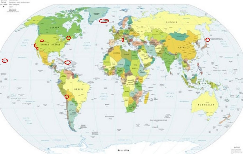
Places to watch.
Good luck to all.
For Wednesday, 30 August 2006.
---------------------------------------
Dominican Republic/Puerto Rico (MEDIUM)
---------------------------------------
2.6 2006/08/30 21:59:53 18.846N -64.678W 49.3 40 km (25 mi) WNW of Settlement, Anegada, British Virgin Islands
3.0 2006/08/30 20:01:45 19.018N -65.457W 71.4 77 km (48 mi) NNE of Luquillo, PR
2.3 2006/08/30 05:03:32 18.559N -66.892W 16.7 10 km ( 6 mi) NNW of Camuy, PR
2.9 2006/08/30 04:12:18 18.279N -67.291W 87.2 7 km ( 4 mi) SW of Stella, PR
Central Italy
---------------------------------------
2006-08-30 11:24:27.0 43.75N 12.14E 8 ML2.4 CENTRAL ITALY
2006-08-30 10:01:51.0 43.78N 12.18E 2 ML3.7 CENTRAL ITALY
volcanolve
37.73 N, 15.00 E, summit elevation 3350 m, Shield volcano
Saturday 2nd September 2006
New eruptions have begun at Mt etna volcano in Italy. Seismic activity was reported on the evening of 30th August. On the morning of 31st August Strombolian eruptions were observed at SE crater. Regular explosions occurred every 5-10 seconds.
Hawaii
---------------------------------------
2.0 2006/08/31 07:01:05 19.321 -155.049 44.9 19 km ( 12 mi) SSE of Fern Forest, HI
2.5 2006/08/31 20:46:49 19.479 -154.887 1.0 4 km ( 2 mi) E of Leilani Estates, HI
Utah/Wyoming area
---------------------------------------
06/08/29 04:45:00 39.61N 110.41W 1.6 1.7 4.5 mi NNW of E. Carbon City
06/08/29 08:21:14 39.62N 110.39W 1.4 1.8 4.6 mi NNW of Sunnyside
06/08/29 21:08:38 39.73N 110.74W 0.5 1.0 6.8 mi NE of Helper
06/08/30 05:37:47 39.41N 111.22W 0.0 1.6 15.1 mi WNW of Huntington
06/08/30 09:31:09 37.34N 114.16W 2.5 2.1 26.9 mi ESE of Caliente
1.6 2006/08/30 15:18:59 39.403 -111.227 9.0 24 km ( 15 mi) WNW of Huntington, UT
1.8 2006/08/30 18:08:16 39.413 -111.225 7.8 24 km ( 15 mi) ESE of Spring City, UT
Hokkaido (Strong)
---------------------------------------
2006-08-30 18:38:05.0 43.89N 145.30E 80 mb4.9 HOKKAIDO, JAPAN, REGION
Iceland area
---------------------------------------
IRELAND
Origin time Lat Lon Azres Timres Wres Nphase Ntot Nsta Netmag
2006-242:08.25.50.0 55.88 -6.78 1.25 0.37 0.68 2 2 1 2.25?
IRISH SEA
Origin time Lat Lon Azres Timres Wres Nphase Ntot Nsta Netmag
2006-243:11.53.54.0 53.88 -4.88 3.90 0.25 1.23 2 3 1 1.88
NORWAY BASIN
Origin time Lat Lon Azres Timres Wres Nphase Ntot Nsta Netmag
2006-243:11.21.20.0 65.91 -0.51 14.06 0.47 3.99 3 3 2 2.08
NORWAY BASIN
Origin time Lat Lon Azres Timres Wres Nphase Ntot Nsta Netmag
2006-243:10.19.43.0 67.25 -3.21 9.45 0.09 2.45 2 2 1 3.17
TARAPACA, CHILE (-19.313 -69.921)
---------------------------------------
2006-08-31 04:58:20 4.6 24.10S 67.07W 150 Chile-Argentina Border Region
2006-08-31 16:20:27.9 24.26S 66.91W 126 mb5.1 SALTA PROVINCE, ARGENTINA
Huntington, Quebec area (45.00N 74.42W)
---------------------------------------
2.8 2006/08/26 08:08:44 45.623N 74.521W 11.0 85 km (53 mi) NNW of Chateaugay, NY
(I must have missed the symptom for this one.)
Region: NEW YORK
Geographic coordinates: 44.514N, 74.527W
Magnitude: 2.0 Ml
Depth: 9 km
Universal Time (UTC): 31 Aug 2006 15:36:09
Time near the Epicenter: 31 Aug 2006 11:36:09
Local time in your area: 31 Aug 2006 11:36:09
ENE of Ocotillo Wells, CA (33.167 -116.038)
(Third day symptom - STRONG)
---------------------------------------
1.1 2006/08/30 00:15:44 33.642 -116.775 15.8 13 km ( 8 mi) SSW of Idyllwild, CA
2.1 2006/08/30 01:19:52 33.650 -116.763 3.0 12 km ( 7 mi) SSW of Idyllwild, CA
1.5 2006/08/30 12:30:45 32.799 -116.333 0.0 18 km ( 11 mi) E of Pine Valley, CA
1.1 2006/08/30 14:11:46 32.965 -116.332 12.9 24 km ( 15 mi) NE of Pine Valley, CA
1.1 2006/08/30 17:37:54 33.494 -116.570 9.8 12 km ( 7 mi) SE of Anza, CA
1.1 2006/08/30 18:54:56 33.679 -116.784 10.5 10 km ( 6 mi) SW of Idyllwild, CA
1.3 2006/08/30 20:00:15 33.308 -116.348 11.8 7 km (4 mi) NNE of Borrego Springs, CA
1.9 2006/08/30 21:19:55 32.711 -116.055 7.0 6 km ( 4 mi) WSW of Ocotillo, CA
The Parkfield Fault
---------------------------------------
1.6 2006/08/30 20:57:42 36.971 -121.608 3.9 5 km ( 3 mi) SSW of Gilroy, CA
1.3 2006/08/31 15:50:40 36.509 -121.091 4.1 5 km ( 3 mi) ESE of Pinnacles, CA
Peace to all.

posted by Unknown @ 1:24 PM
0 comments
![]()
![]()
