*For Saturday, 11 February 2006.
LEGEND for OVERVIEW:
Size = My surety of area for quake.
Red Circle = Probable quake to STRONG quake.
Triangle = Very Strong or Stronger quake (And usually takes extra days).
Blue Circle, etc. = Uncertainty of symptom area for probable quake.

Places to watch.
Good luck to all.
For Saturday, 11 February 2006.
----------------------------------------
Nicobar/Andaman Islands area (Three different symptoms - STRONG)
----------------------------------------
(Some occurred on the 13th. Posted them there.)
Possibly Glacier Peak/Mt. Rainier area
----------------------------------------
map 1.0 2006/02/11 17:55:38 46.587N 122.759W 20.9 21 km (13 mi) SE of Centralia, WA
map 1.2 2006/02/11 03:57:47 47.070N 122.010W 15.8 15 km ( 9 mi) S of Enumclaw, WA
map 2.9 2006/02/11 03:47:56 47.473N 121.800W 7.6 3 km ( 2 mi) SSW of North Bend, WA
map 1.3 2006/02/11 01:06:46 48.267N 119.284W 1.3 24 km (15 mi) ESE of Okanogan, WA
1.3 2006/02/12 01:47:30 48.488N 121.850W 2.0 9 km ( 6 mi) SW of Concrete, WA
1.2 2006/02/12 18:17:41 48.872N 122.157W 7.9 7 km ( 4 mi) NE of Deming, WA
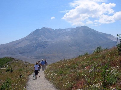
Mt. St. Helen's (This is a continuation of what started the night before but is now firmly at Mt. St. Helen's - EXTREMELY STRONG. This included bouts of heart pounding which may mean large quake.)
----------------------------------------
map 2.6 2006/02/12 11:30:26 46.194N 122.186W 0.0 1 km ( 0 mi) SE of Mount St. Helens
map 2.8 2006/02/13 15:05:29 46.201N 122.182W 0.0 1 km ( 0 mi) ENE of Mount St. Helens
(This has not happened yet...but there is NOW some activity at the volcano. Extremely Strong symptoms can take 5 or more extra days. I am updating on the 17th and just now the seismograms are getting active.)
pnsn webicorder
Petrolia and North of
----------------------------------------
(Nothing found)
Czech and Slovak Republics (49.75N 18.41E)
----------------------------------------
2006-02-12 12:14:05.4 50.45N 13.53E ML2.0 CZECH AND SLOVAK REPUBLICS
Quinghai, China area (33.76N 91.24E)
----------------------------------------
2006-02-11 05:04:17.5 27.22N 92.19E 33f mb5.0 EASTERN XIZANG-INDIA BDR REG.
Mona Canyon area (18.851N 67.415W) then Puerto Rico (STRONG for both)
----------------------------------------
MAP 3.5 2006/02/11 00:38:12 18.878 -64.618 26.2 35 km ( 22 mi) WNW of Settlement, British Virgin Islands
MAP 2.9 2006/02/11 03:23:51 18.660 -67.004 76.8 18 km ( 11 mi) N of Isabela, PR
MAP 2.7 2006/02/11 04:56:54 17.952 -66.898 7.7 3 km ( 2 mi) SSW of María Antonia, PR
MAP 3.6 2006/02/11 05:10:25 18.575 -67.990 115.5 76 km ( 47 mi) E of Higüey, Dominican Republic
MAP 2.3 2006/02/11 11:43:54 17.962 -66.889 6.9 2 km ( 1 mi) S of María Antonia, PR
Pinnacles/Parkfield and in between
----------------------------------------
(Nothing found)
France
----------------------------------------
(Nothing found)
Huntington, Utah area (39.443N 111.195W) then more Utah areas
----------------------------------------
map 1.6 2006/02/11 21:15:02 39.666N 110.524W 2.2 16 km (10 mi) NW of E. Carbon City, UT
map 1.2 2006/02/11 18:42:15 39.669N 110.519W 2.0 16 km (10 mi) NW of E. Carbon City, UT
map 1.4 2006/02/11 17:46:19 39.416N 111.211W 6.4 23 km (15 mi) WNW of Huntington, UT
map 1.4 2006/02/11 14:16:52 39.648N 110.539W 2.4 15 km (10 mi) NW of E. Carbon City, UT
map 1.7 2006/02/11 14:01:03 39.412N 111.222W 4.6 24 km (15 mi) WNW of Huntington, UT
map 1.7 2006/02/11 10:07:23 39.415N 111.219W 7.8 24 km (15 mi) WNW of Huntington, UT
map 1.3 2006/02/11 04:49:46 39.668N 110.519W 1.8 16 km (10 mi) NW of E. Carbon City, UT
Hawaii
----------------------------------------
MAP 2.0 2006/02/11 00:07:23 19.384 -155.250 3.0 7 km ( 5 mi) SSW of Volcano, HI
MAP 2.7 2006/02/11 03:19:25 19.388 -155.243 3.8 7 km ( 4 mi) S of Volcano, HI
MAP 2.6 2006/02/11 03:11:24 19.387 -155.241 3.8 7 km ( 4 mi) S of Volcano, HI
MAP 1.8 2006/02/11 02:54:40 19.388 -155.246 3.7 7 km ( 4 mi) S of Volcano, HI
MAP 1.8 2006/02/11 02:38:23 19.420 -155.232 12.0 3 km ( 2 mi) S of Volcano, HI
MAP 2.1 2006/02/11 08:29:52 19.373 -155.234 3.2 9 km ( 5 mi) S of Volcano, HI
MAP 2.9 2006/02/11 15:15:29 19.518 -155.278 24.6 9 km ( 5 mi) NNW of Volcano, HI
MAP 2.0 2006/02/11 15:38:54 19.381 -155.241 3.6 8 km ( 5 mi) S of Volcano, HI
Honshu, Japan and South of
----------------------------------------
2006-02-11 23:12:04.2 35.57N 141.26E 33 mb 4.7 NEAR E.CST EASTERN HONSHU
Southern Italy then Central Italy (Medium for Central Italy)
----------------------------------------
2006-02-11 19:57:33.0 43.30N 12.85E 9 ML2.2 CENTRAL ITALY
Newfoundland/New Brunswick/Quebec area
----------------------------------------
2006/02/12 20:02:24 48.97N 67.53W 18.0g 1.0MN GSC 14 km N from Matane, QC
2006/02/12 13:00:43 49.19N 67.74W 18.0g 2.5MN GSC 30 km E from Baie-Comeau, QC
2006/02/12 07:23:28 49.41N 65.98W 14.9 1.5MN GSC 49 km NE from Sainte-Anne-des-Monts, QC
San Clemente Island, California (32.605 -118.112)
----------------------------------------
MAP 2.7 2006/02/11 20:18:19 33.444 -118.948 0.0 56 km ( 35 mi) NW of San Clemente Is., CA (NW tip)
Yukon/Northwest Territories
----------------------------------------
2006/02/10 05:29:25 64.21N 138.72W 20F 1.4 38 km ENE Dawson YT
2006/02/10 04:36:10 60.53N 141.63W 10F 2.8 184 km NW Yakutat AK
Northcentral Iran
----------------------------------------
(Nothing found)
Possibly Western India (New symptom)
----------------------------------------
MAP 4.7 2006/02/11 05:04:21 27.280 92.258 43.5 ARUNACHAL PRADESH, INDIA
Possibly West of Macquarie Island (53.46S 140.64E) (If this area quakes it will prove a new symptom.)
----------------------------------------
2006-02-11 21:49:13.9 25.84S 2.48W 33 mb4.9 SOUTH ATLANTIC OCEAN?
(This is more likely the area for the symptom - I will have to wait for more quakes for confirmation.)
Peace to all.

posted by Unknown @ 2:17 PM
0 comments
![]()
![]()
