*For Saturday, 11 March 2006.
LEGEND for OVERVIEW:
Size = My surety of area for quake.
Red Circle = Probable quake to STRONG quake.
Triangle = Very Strong or Stronger quake (And usually takes extra days).
Blue Circle, etc. = Uncertainty of symptom area for probable quake.
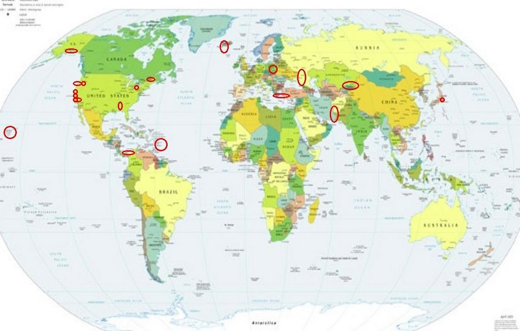
Places to watch.
Good luck to all.
For Saturday, 11 March 2006.
----------------------------------------
Hawaii (Strong)
----------------------------------------
MAP 1.8 2006/03/11 09:47:30 19.376 -155.496 7.9 19 km ( 12 mi) N of Pahala, HI
MAP 1.9 2006/03/11 13:27:26 19.450 -155.304 5.5 7 km ( 4 mi) W of Volcano, HI
MAP 2.0 2006/03/11 14:40:13 19.570 -155.326 11.9 16 km ( 10 mi) NW of Volcano, HI
MAP 1.9 2006/03/11 15:47:35 19.387 -155.281 2.9 8 km ( 5 mi) SW of Volcano, HI
MAP 2.7 2006/03/11 19:39:49 19.382 -155.283 2.6 9 km ( 6 mi) SW of Volcano, HI
MAP 1.7 2006/03/11 23:56:56 19.384 -155.282 2.8 9 km ( 5 mi) SW of Volcano, HI
San Simeon/Lake Nacimiento area
----------------------------------------
MAP 2.4 2006/03/10 07:03:56 35.709 -121.073 8.6 13 km ( 8 mi) NE of San Simeon, CA
The Coast of Oregon (2 different areas and may be close to Petrolia - indication of a deep quake. Medium.)
----------------------------------------
MAP 4.5 2006/03/09 16:23:36 42.383 -126.576 10.0 175 km (109 mi) WSW of Port Orford, OR
(2 Days early)
Turkey/Greece area (MEDIUM)
----------------------------------------
2006-03-11 08:23:19.0 36.90N 22.47E ML3.3 SOUTHERN GREECE
The New Madrid/Possibly Arkansas or Mississippi
----------------------------------------
MAP 2.7 2006/03/11 02:37:20 35.190 -88.010 2.6 21 km ( 13 mi) E of Savannah, TN
MAP 1.7 2006/03/11 17:43:29 36.500 -89.570 8.4 4 km ( 3 mi) ESE of Marston, MO
MAP 2.0 2006/03/12 03:10:32 36.210 -89.480 6.6 6 km ( 4 mi) S of Ridgely, TN
MAP 1.8 2006/03/12 17:24:06 36.200 -89.570 6.1 8 km ( 5 mi) ENE of Caruthersville, MO
Possibly Coburg, OR area (44.113 -123.031) (MEDIUM)
----------------------------------------
(Nothing found)
Reykjanes Ridge area
----------------------------------------
2006-03-10 15:55:56.4 63.58N 23.29W 1 ML3.6 ICELAND REGION
Poland (Medium)
----------------------------------------
(Nothing found)
Southern Alaska (Indication of a deep quake - Strong)
----------------------------------------
MAP 2.5 2006/03/10 04:05:08 59.521 -152.761 5.0 SOUTHERN ALASKA
MAP 2.5 2006/03/10 04:33:28 61.387 -151.182 60.0 SOUTHERN ALASKA
MAP 3.1 2006/03/10 07:43:56 59.977 -153.952 160.0 SOUTHERN ALASKA
MAP 2.6 2006/03/10 09:25:15 61.023 -151.418 70.0 SOUTHERN ALASKA
Los Angeles (Strong)
----------------------------------------
MAP 1.1 2006/03/10 08:57:40 34.456 -118.036 9.6 9 km ( 5 mi) SSW of Littlerock, CA
MAP 1.1 2006/03/10 18:03:01 34.459 -118.039 9.9 9 km ( 5 mi) SSW of Littlerock, CA
MAP 1.9 2006/03/11 11:57:08 34.452 -118.034 9.9 9 km ( 6 mi) SSW of Littlerock, CA
MAP 1.9 2006/03/12 03:13:41 33.916 -117.770 11.5 4 km ( 2 mi) NNE of Yorba Linda, CA
MAP 2.1 2006/03/12 05:36:42 34.011 -117.575 4.7 6 km ( 4 mi) WNW of Mira Loma, CA
MAP 2.6 2006/03/12 13:10:01 33.417 -118.099 3.0 23 km ( 14 mi) ENE of Avalon, CA
San Francisco (Medium)
----------------------------------------
MAP 2.0 2006/03/11 22:22:33 37.800 -122.606 12.6 7 km ( 5 mi) SSW of Muir Beach, CA
MAP 2.6 2006/03/11 22:12:29 37.798 -122.591 13.5 7 km ( 5 mi) S of Muir Beach, CA
Western Iran (32.63 N 49.59 E) (Medium)
----------------------------------------
2006-03-10 09:41:46.5 27.91N 57.08E 52 mb 4.3 SOUTHERN IRAN
2006-03-10 17:56:42.7 36.93N 45.50E 7 M3.8 IRAN-IRAQ BORDER REGION
2006-03-11 17:58:44.6 32.14N 50.68E 4 M3.1 NORTHERN AND CENTRAL IRAN
2006-03-11 21:33:41.7 27.86N 56.91E 80 mb5.0 SOUTHERN IRAN
Panama/Colombia area (Medium)
----------------------------------------
06/03/11 22:21:41 10.67N 85.31W 157.9 3.7ML Costa Rica
06/03/11 21:27:39 10.93N 86.44W 5.1 2.8ML Frente a San Juan del Sur
06/03/11 17:42:09 12.70N 87.71W 83.7 3.0ML Frente al Cosigüina
06/03/11 17:38:53 11.31N 86.03W 68.5 3.5ML Frente a San Juan del Sur
06/03/11 12:16:34 12.99N 88.30W 15.0 3.3MC Frente a El Salvador
Possibly Quebec/Maine border area (Strong)
----------------------------------------
2006/03/10 07:59:55 49.12N 67.76W 18.0g 1.7MN GSC 30 km E from Baie-Comeau, QC
2006/03/10 05:51:55 47.25N 70.69W 18.0g 1.6MN GSC 26 km SW from Baie-Saint-Paul, QC
NNW of East End-Long Look, British Virgin Islands (18.538 -64.589) then slightly into Atlantic Ocean (Unusual pressure pain - STRONG)
----------------------------------------
MAP 2.1 2006/03/11 04:15:06 17.837 -67.039 45.4 15 km ( 9 mi) S of La Parguera, PR
MAP 3.0 2006/03/11 08:26:20 18.152 -67.231 101.2 9 km ( 6 mi) NNW of Puerto Real, PR
MAP 3.4 2006/03/11 11:34:49 18.994 -63.711 22.2 71 km ( 44 mi) ENE of Settlement, British Virgin Islands
MAP 3.1 2006/03/11 19:16:48 18.948 -65.354 9.6 72 km ( 44 mi) N of Culebra, PR
North of Eastlake, Ohio (41.657 -81.430) and South of Mentor-on-the-Lake (41.770 -81.450)
----------------------------------------
MAP 3.1 2006/03/11 12:27:15 41.780 -81.390 5.0 8 km ( 5 mi) NNW of Mentor-on-the-Lake, OH
Kazakhstan/Kyrgyzstan border area (Medium)
----------------------------------------
2006-03-11 21:01:19.6 38.63N 53.93E 18 M3.2 TURKMENISTAN
Honshu, Japan
----------------------------------------
2006-03-11 22:06:39.6 40.44N 142.31E 5 mb5.2 NEAR E.CST EASTERN HONSHU
2006-03-11 04:31:24.7 28.44N 127.02E 400 mb 4.4 NW.OF RYUKYU ISLANDS, JAPAN
2006-03-11 04:30:17.4 24.06N 126.80E 40 mb 4.6 RYUKYU ISLANDS, JAPAN
The Geysers and South of
----------------------------------------
MAP 3.1 2006/03/10 02:03:54 38.807 -122.796 4.9 1 km ( 1 mi) NE of The Geysers, CA
MAP 2.6 2006/03/10 04:33:15 38.801 -122.798 2.0 1 km ( 1 mi) ENE of The Geysers, CA
MAP 2.0 2006/03/10 04:38:02 38.799 -122.800 0.8 1 km ( 0 mi) E of The Geysers, CA
MAP 1.7 2006/03/10 17:54:04 38.846 -122.825 2.2 5 km ( 3 mi) NNW of The Geysers, CA
MAP 1.3 2006/03/10 19:16:36 38.864 -122.811 1.7 7 km ( 5 mi) N of The Geysers, CA
MAP 1.8 2006/03/10 20:17:05 38.826 -122.803 0.8 3 km ( 2 mi) N of The Geysers, CA
MAP 1.6 2006/03/10 20:48:24 38.828 -122.781 2.5 4 km ( 2 mi) NE of The Geysers, CA
MAP 2.1 2006/03/11 09:37:53 38.804 -122.796 4.5 1 km ( 1 mi) NE of The Geysers, CA
MAP 2.3 2006/03/11 09:37:18 38.790 -122.774 2.1 3 km ( 2 mi) ESE of The Geysers, CA
MAP 1.3 2006/03/11 17:52:13 38.806 -122.794 2.2 1 km ( 1 mi) NE of The Geysers, CA
MAP 1.1 2006/03/11 18:03:38 38.821 -122.809 3.5 3 km ( 2 mi) N of The Geysers, CA
MAP 1.4 2006/03/11 19:42:19 38.830 -122.875 1.6 7 km ( 4 mi) WNW of The Geysers, CA
MAP 1.7 2006/03/11 23:52:17 38.757 -122.709 2.2 2 km ( 2 mi) SW of Anderson Springs, CA
MAP 1.7 2006/03/11 23:57:09 38.761 -122.728 2.0 3 km ( 2 mi) WSW of Anderson Springs, CA
MAP 1.5 2006/03/12 02:12:06 38.823 -122.792 4.0 3 km ( 2 mi) NNE of The Geysers, CA
MAP 1.2 2006/03/12 03:49:40 38.828 -122.805 2.7 3 km ( 2 mi) N of The Geysers, CA
MAP 2.0 2006/03/12 04:45:19 38.806 -122.789 1.5 2 km ( 1 mi) ENE of The Geysers, CA
MAP 2.2 2006/03/12 04:46:45 38.819 -122.811 4.6 2 km ( 1 mi) N of The Geysers, CA
MAP 1.8 2006/03/12 05:09:32 38.825 -122.805 1.9 3 km ( 2 mi) N of The Geysers, CA
MAP 1.7 2006/03/12 06:48:52 38.819 -122.784 2.3 3 km ( 2 mi) NE of The Geysers, CA
MAP 1.7 2006/03/12 12:03:43 38.818 -122.785 2.3 3 km ( 2 mi) NE of The Geysers, CA
MAP 1.4 2006/03/12 19:52:41 38.836 -122.855 1.3 6 km ( 4 mi) NW of The Geysers, CA
MAP 1.5 2006/03/12 23:55:38 38.828 -122.805 2.6 3 km ( 2 mi) N of The Geysers, CA
Southwestern Siberia (Medium)
----------------------------------------
2006-03-13 11:44:02.0 53.61N 87.28E ML3.2 SOUTHWESTERN SIBERIA, RUSSIA
(2 extra days)
Peace to all.

posted by Unknown @ 11:53 AM
0 comments
![]()
![]()
