*For Saturday, 1 April 2006.
LEGEND for OVERVIEW: Size = My surety of area for quake.
Red Circle = Probable quake to STRONG quake.
Triangle = Very Strong or Stronger quake (And usually takes extra days).
Blue Circle, etc. = Uncertainty of symptom area for probable quake.
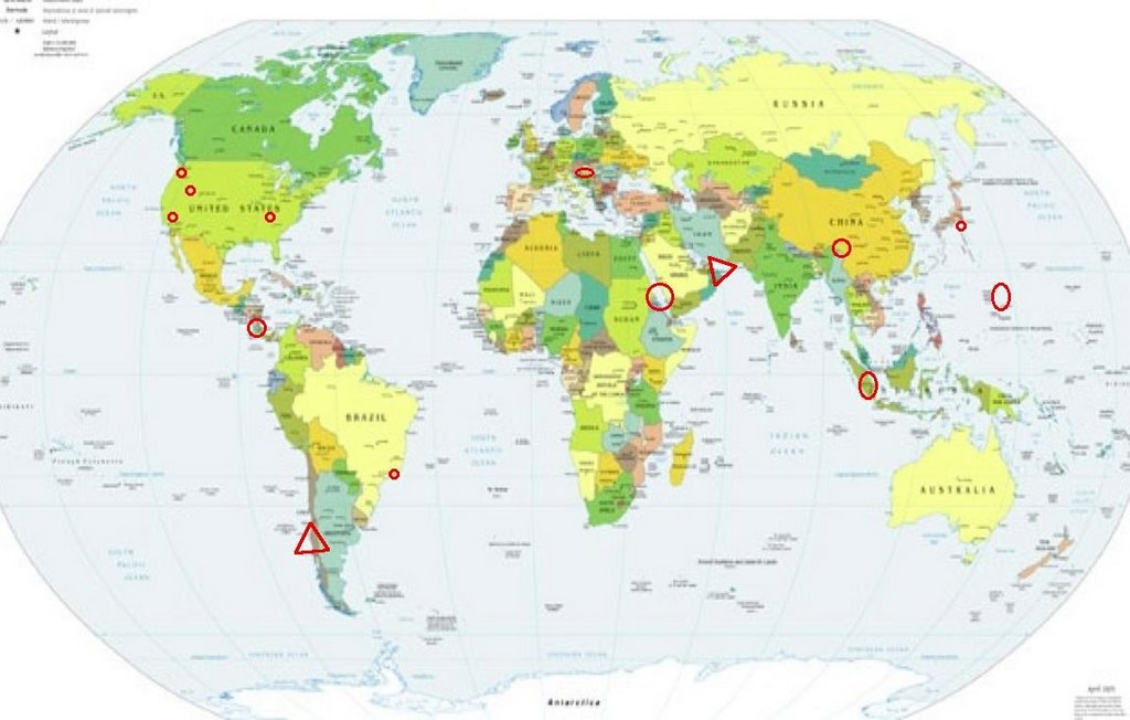
Places to watch.
Good luck to all.
For Saturday, 1 April 2006.
----------------------------------------
Ridgecrest, California area ( 35.630 -117.602) (Medium)
----------------------------------------
MAP 1.4 2006/04/01 04:27:45 34.234 -117.611 11.3 7 km ( 4 mi) SSE of Mt. Baldy, CA
MAP 1.3 2006/04/01 04:08:42 34.148 -117.596 12.7 3 km ( 2 mi) NNW of Rancho Cucamonga, CA
MAP 1.4 2006/04/01 10:36:09 34.240 -117.542 8.0 11 km ( 7 mi) ESE of Mt. Baldy, CA
Eastern Tenneessee Seismic Zone/Ridgely, Tennesse area (36.250N 89.450W)
----------------------------------------
map 1.7 2006/04/02 03:35:45 36.130N 89.440W 11.1 12 km ( 7 mi) NNW of Dyersburg, TN
map 1.0 2006/04/01 06:42:37 35.720N 84.300W 20.3 3 km ( 2 mi) ESE of Loudon, TN
Mt. St. Helen’s
----------------------------------------
MAP 1.0 2006/04/01 05:40:21 46.196 -122.195 0.0 1 km ( 1 mi) WSW of Mount St. Helens Volcano, WA
MAP 1.2 2006/04/01 16:38:08 46.197 -122.193 0.9 1 km ( 1 mi) WSW of Mount St. Helens Volcano, WA
Rio de Janeiro, Brazil area (MEDIUM)
----------------------------------------
2006-04-03 03:33:47 5.3 8.96 S 70.98 W Western Brazil
(Brazil...but not near the coast at all! I will watch for a repeat to prove the symptom.)
Czech and Slovak Republics (50.48N 13.52) (MEDIUM)
----------------------------------------
2006-04-03 10:16:59 3.5 49.57 N 18.59 E Czech And Slovak Republics
(2 extra days)
Nicaragua/Costa Rica area (Strong)
----------------------------------------
MAP 4.3 2006/03/31 02:47:22 10.717 -86.563 50.0 OFF THE COAST OF COSTA RICA
06/04/01 19:34:58 12.90N 86.60W 1.0 2.2ML Nicaragua
06/04/01 19:19:52 12.69N 86.82W 5.3 1.4ML Nicaragua
06/04/01 15:58:42 12.31N 87.70W 12.8 2.7MC Frente al Cosigüina
06/04/01 13:14:41 10.41N 86.68W 1.9 3.8MC Oceano Pacífico de Nicaragua
06/04/01 11:53:28 10.71N 86.61W 6.4 4.0ML Frente a San Juan del Sur
06/04/01 10:32:47 12.19N 86.16W 9.8 2.1MC Sur del Lago de Managua
06/04/01 06:41:12 10.40N 86.67W 2.0 4.4MC Oceano Pacífico de Nicaragua
06/04/01 03:24:19 12.44N 88.18W 15.7 3.0MC Frente al Golfo de Fonseca
Off the East Coast of Honshu, Japan (34.99 N 141.31)
----------------------------------------
2006-04-01 05:23:22 5.3 34.12 N 145.19 E Off East Coast of Honshu, Japan
2006-04-01 05:57:56 4.9 27.01 N 141.33 E Bonin Islands, Japan Region
2006-04-01 06:34:43.8 38.62 N 144.18 E 500 mb 4.6 OFF EAST COAST OF HONSHU, JAPAN
02Apr2006 00:37:59.8 34.1N 136.1E320 mb=4.9 M*GSR WESTERN HONSHU, JAPAN
02Apr2006 07:22:52.9 38.6N 141.7E 50 mb=4.9 M*GSR NEAR EAST COAST OF HONSHU,
02Apr2006 11:23:26.7 29.9N 142.0E 60 mb=4.9 M*GSR SOUTH OF HONSHU, JAPAN
Xizang to Myanmar area (32.3N 95.1E) (STRONG)
----------------------------------------
MAP 4.1 2006/04/01 12:35:10 32.739 93.536 35.0 XIZANG-QINGHAI BORDER REGION
Sumatra (Strong)
----------------------------------------
2006-04-01 10:34:48.6 2.29N 94.94E 29 M 5.0 OFF W. CST OF NORTHERN SUMATERA
2006-04-02 08:30:27 5.2 2.71 N 96.48 E Northern Sumatra, Indonesia
Red Sea area (27.88N 34.41E) (Second day symptoms and harder - STRONG.)
----------------------------------------
(Nothing found)
Mariana Islands (Strong)
----------------------------------------
MAP 4.3 2006/04/01 03:24:29 17.778 145.928 142.5 ALAMAGAN REG., NORTHERN MARIANA ISLANDS
MAP 5.1 2006/04/01 05:44:18 18.562 145.280 522.9 PAGAN REGION, NORTHERN MARIANA ISLANDS
Utah
----------------------------------------
MAP 2.1 2006/04/01 01:10:58 38.992 -111.331 5.0 10 km ( 6 mi) NW of Emery, UT
MAP 1.4 2006/04/01 05:17:48 39.671 -110.515 1.3 16 km ( 10 mi) NW of Sunnyside, UT
MAP 2.1 2006/04/01 05:02:31 39.457 -111.214 5.4 23 km ( 14 mi) ESE of Mount Pleasant, UT
MAP 1.4 2006/04/01 06:06:09 39.619 -110.417 1.4 8 km ( 5 mi) N of Sunnyside, UT
MAP 1.4 2006/04/01 06:54:44 39.672 -110.513 1.5 16 km ( 10 mi) NW of Sunnyside, UT
MAP 1.6 2006/04/01 07:45:58 39.458 -111.200 3.7 24 km ( 15 mi) ESE of Mount Pleasant, UT
MAP 1.5 2006/04/01 09:37:42 39.669 -110.519 2.6 16 km ( 10 mi) NNW of East Carbon, UT
MAP 1.6 2006/04/01 15:20:21 39.608 -110.393 0.8 6 km ( 4 mi) N of Sunnyside, UT
MAP 1.6 2006/04/01 18:24:06 39.672 -110.523 4.4 17 km ( 11 mi) NNW of East Carbon, UT
MAP 1.7 2006/04/01 19:35:24 39.608 -110.392 0.9 6 km ( 4 mi) N of Sunnyside, UT
Gulf of Oman area/Southern Iran (VERY STRONG and indication of deep quake.)
(Some sites - off site, do not work.)
http://www.geocities.com/Heartland/Acres/2692/>Heartland
----------------------------------------
2006-03-31 02:48:32.5 33.78 N 48.69 E 18 M 3.5 WESTERN IRAN
2006-03-31 02:42:36.0 33.81 N 48.66 E M 3.1 WESTERN IRAN
2006-03-31 02:12:29.6 33.73 N 48.60 E 8 M 3.1 WESTERN IRAN
2006-03-31 02:08:59.4 33.90 N 48.67 E 9 M 3.1 WESTERN IRAN
2006-03-31 01:31:23.4 33.72 N 48.71 E 20 mb 5.1 WESTERN IRAN
2006-03-31 01:17:00.2 33.63 N 48.76 E 10 mb 5.7 WESTERN IRAN
2006-03-31 02:58:30.6 33.79 N 48.54 E 4 M 3.4 WESTERN IRAN
2006-03-31 05:08:33.0 33.42 N 48.81 E 23 M 3.1 WESTERN IRAN
2006-03-31 05:03:10.8 33.43 N 48.84 E 18 M 3.0 WESTERN IRAN
2006-03-31 05:43:07.7 33.83 N 48.47 E 18 M 3.1 WESTERN IRAN
2006-03-31 07:23:36.7 33.71 N 48.73 E 18 M 3.0 WESTERN IRAN
2006-03-31 09:56:29.4 33.34 N 48.86 E 29 M 3.0 WESTERN IRAN
2006-03-31 09:40:30.5 33.75 N 48.88 E 32 M 3.2 WESTERN IRAN
2006-03-31 09:23:39.6 33.79 N 48.76 E 27 M 3.4 WESTERN IRAN
2006-03-31 07:58:23.6 33.79 N 48.65 E 19 M 3.2 WESTERN IRAN
2006-03-31 11:54:00.3 33.61 N 48.77 E 10 mb 4.8 WESTERN IRAN
2006-03-31 11:43:46.6 33.43 N 47.27 E 18 M 3.6 WESTERN IRAN
2006-03-31 13:50:02.4 33.68 N 48.65 E 6 M 3.1 WESTERN IRAN
2006-03-31 16:02:51.6 33.63 N 48.67 E 18 M 3.1 WESTERN IRAN
2006-03-31 15:30:12.1 33.63 N 48.85 E 18 M 3.5 WESTERN IRAN
2006-03-31 20:04:17.4 33.67 N 48.83 E 18 M 3.0 WESTERN IRAN
(I also posted this as possible for the Very Strong for Nepal for the 29th of March - this is at least closer to the Very Strong for Southern Iran. I will need to hone in on the symptoms better to see which one was the right area.)
Northern Chile (21.9S 69.0W) then further South (.-30.691 -71.451) (VERY STRONG for the Southern Chile quakes and indication of deep quake.)
http://www.geographia.com/chile/>geographia
----------------------------------------
31/03/2006 22:42:49 -33.571 -70.964 78.5 3.8Mc GUC 4.1Ml GUC33 km al O de Santiago
(Nothing found for Northern Chile)
Peace to all.

posted by Unknown @ 12:06 PM
0 comments
![]()
![]()
