*For Saturday, 16 December 2006.
LEGEND for OVERVIEW: Size = My surety of area for quake.
Red Circle = Probable quake to STRONG quake.
Triangle = Very Strong/Stronger quake (Usually takes extra days).
Blue Circle, etc. = Uncertainty of symptom area for probable quake.
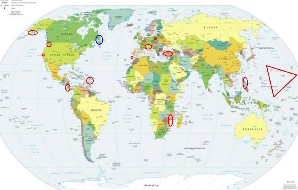
Places to watch.
Good luck to all.
For Saturday, 16 December 2006.
--------------------------------------
Poland (Strong)
--------------------------------------
2006-12-16 06:38:03.3 49.77N 18.62E 4 ML2.4 POLAND-CZECH REPUBLIC-SLOVAKIA
2006-12-16 05:52:55.0 49.87N 18.14E 8 ML2.3 POLAND-CZECH REPUBLIC-SLOVAKIA
2006-12-16 04:54:46.8 51.26N 15.75E 2 ML3.0 POLAND
2006-12-16 02:30:53.5 49.48N 18.62E 2 ML3.3 POLAND-CZECH REPUBLIC-SLOVAKIA
Strait of Gibraltar
--------------------------------------
2006-12-16 19:34:33.4 36.36N 0.90E 30f mb4.6 NORTHERN ALGERIA?
Pinnacles and East of (36.448 -121.008)
(Indication of depth - Strong)
--------------------------------------
1.8 2006/12/16 02:43:34 36.457 -121.034 5.2 13 km ( 8 mi) SE of Pinnacles, CA
1.2 2006/12/16 08:33:38 36.582 -121.078 6.8 8 km ( 5 mi) NE of Pinnacles, CA
1.9 2006/12/16 13:28:33 36.463 -121.040 7.9 12 km ( 7 mi) SE of Pinnacles, CA
1.4 2006/12/16 17:13:43 36.544 -121.053 6.7 8 km ( 5 mi) E of Pinnacles, CA
2.2 2006/12/17 08:06:34 37.372 -121.733 5.8 8 km ( 5 mi) E of Alum Rock, CA
1.1 2006/12/17 10:03:29 36.838 -121.462 4.9 6 km ( 4 mi) W of Hollister, CA
1.7 2006/12/17 10:37:24 37.342 -121.716 1.4 10 km ( 6 mi) ESE of Alum Rock, CA
1.8 2006/12/17 13:21:49 36.909 -121.637 6.1 2 km ( 2 mi) N of Aromas, CA
2.2 2006/12/17 14:35:13 37.000 -121.194 0.2 25 km ( 15 mi) NE of Hollister, CA
1.3 2006/12/17 17:11:57 36.636 -121.120 8.7 12 km ( 7 mi) N of Pinnacles, CA
Washington but not Mt. St. Helen’s
(Still having trouble pinpointing.)
--------------------------------------
1.1 2006/12/16 18:18:46 46.252 -120.462 0.0 18 km ( 11 mi) SSE of Harrah, WA
Aleutians/Kenai Peninsula area
--------------------------------------
2006-12-16 18:07:08 4.6mb 50.88N 177.85W 20 Andreanof Islands, Aleutian Islands
2006-12-16 21:35:57.0 51.13N 177.75W 60 mb4.9 ANDREANOF ISLANDS, ALEUTIAN IS.
Possibly Newfoundland area (Unproven symptom)
--------------------------------------
2006/12/16 16:17:22 43.80N 58.50W 18.0* 2.0ML 120 km E of Sable Island,NS
Mariana Islands to Volcano Islands
(I first attributed this symptom to prolonged
walking but it has persisted for more than
2 days now - VERY STRONG.)
travellerspoint.com
--------------------------------------
2006-12-15 17:20:05 4.8mb 2.54N 144.67E 260 South of Mariana Islands
The Philippines (Strong)
--------------------------------------
4.6 2006/12/16 02:14:36 5.223 125.930 53.4 MINDANAO, PHILIPPINES
4.4 2006/12/16 02:10:03 5.389 126.010 49.2 MINDANAO, PHILIPPINES
The Virgin Islands (Strong)
--------------------------------------
3.5 2006/12/16 10:25:48 19.249N -64.784W 50.4 76 km (47 mi) NW of Settlement, Anegada, British Virgin Islands
Mozmbique area
--------------------------------------
(Nothing found)
Turkey
--------------------------------------
2006-12-16 01:44:38.6 39.40N 26.01E 10 ML3.2 NEAR THE COAST OF WESTERN TURKEY
2006-12-16 13:40:50.7 39.45N 33.09E 5 MD3.0 CENTRAL TURKEY
2006-12-16 15:41:50.5 38.64N 26.61E 5 MD3.1 NEAR THE COAST OF WESTERN TURKEY
2006-12-16 21:05:51.4 38.65N 31.09E 5 MD3.0 WESTERN TURKEY
2006-12-16 21:13:58.3 38.40N 38.41E 7 MD3.0 EASTERN TURKEY
2006-12-16 23:13:46.9 38.36N 38.47E 13 MD3.1 EASTERN TURKEY
2006-12-16 22:56:38.2 40.32N 37.38E 6 MD3.2 CENTRAL TURKEY
2006-12-17 03:02:54.3 37.84N 27.01E 8 ML3.4 WESTERN TURKEY
2006-12-17 03:24:03.4 38.65N 39.68E 5 MD2.9 EASTERN TURKEY
2006-12-17 08:06:01.1 44.30N 7.64E 2 ML2.6 NORTHERN ITALY
2006-12-17 06:26:43.8 44.50N 9.78E 30 ML2.9 NORTHERN ITALY
2006-12-17 04:23:13.6 39.64N 42.93E 4 MD3.3 EASTERN TURKEY
2006-12-17 06:13:11.3 37.89N 27.11E 6 MD3.1 WESTERN TURKEY
2006-12-17 08:55:05.5 39.01N 41.21E 8 MD3.3 EASTERN TURKEY
2006-12-17 10:31:25.6 39.59N 42.77E 7 MD3.4 EASTERN TURKEY
2006-12-17 10:58:01.0 39.01N 31.14E 6 MD2.9 WESTERN TURKEY
2006-12-17 15:47:41.4 39.58N 34.87E 12 MD3.0 CENTRAL TURKEY
2006-12-17 17:55:11.7 38.26N 37.28E 9 MD3.1 CENTRAL TURKEY
2006-12-17 19:46:34.6 36.78N 33.74E 5 MD3.4 CENTRAL TURKEY
2006-12-17 20:49:36.2 36.79N 33.68E 13 MD3.1 CENTRAL TURKEY
2006-12-17 23:26:04.1 39.43N 42.74E 8 MD3.2 EASTERN TURKEY
2006-12-17 22:02:47.2 39.20N 41.47E 4 MD3.2 EASTERN TURKEY
Frente a La Boquita y Casares
(10.78N 87.29W)
--------------------------------------
06/12/16 08:24:40 10.77N 86.44W 16.1 3.2ML Frente a San Juan del Sur
06/12/15 06:51:41 10.62N 85.14W 79.3 3.4ML Costa Rica
Switzerland to Central Italy
--------------------------------------
2006-12-16 14:35:19.0 43.35N 12.37E 62 ML2.9 CENTRAL ITALY
Peace to all.

posted by Unknown @ 2:04 PM
0 comments
![]()
![]()
