*For Monday, 28 August 2006.
LEGEND for OVERVIEW: Size = My surety of area for quake.
Red Circle = Probable quake to STRONG quake.
Triangle = Very Strong/Stronger quake (Usually takes extra days).
Blue Circle, etc. = Uncertainty of symptom area for probable quake.
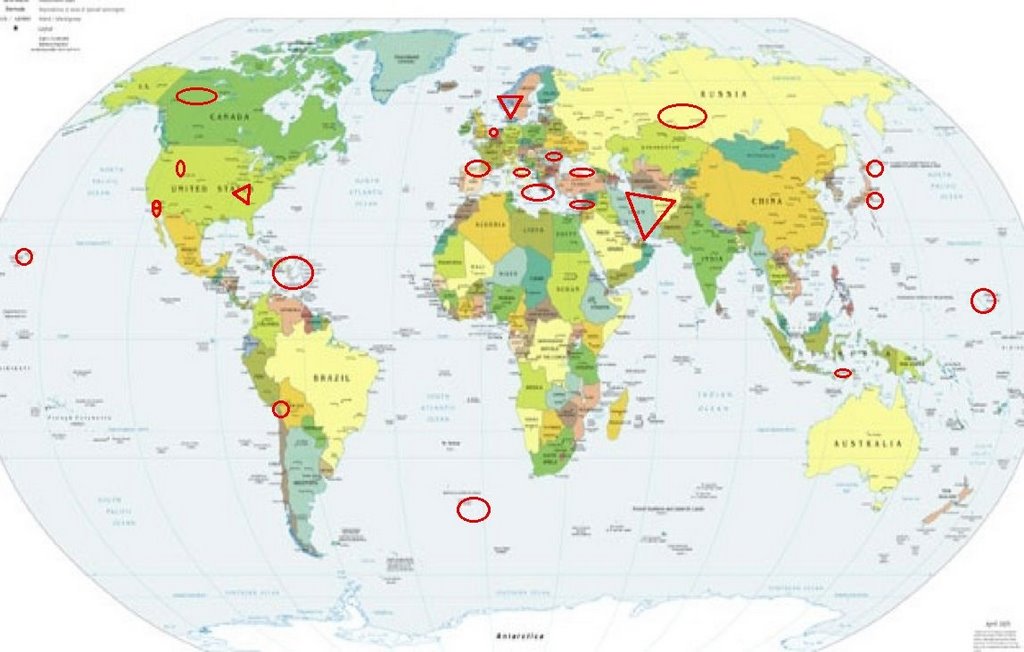
Places to watch.
Good luck to all.
For Monday, 28 August 2006.
---------------------------------------
Southern Norway area (61.63N 11.60E)
(Very Strong)
www.nd.edu

---------------------------------------
NORWAY-MURMANSK BORDER REGION
Origin time Lat Lon Azres Timres Wres Nphase Ntot Nsta Netmag
2006-239:18.29.44.0 69.28 29.90 13.73 0.82 4.26 3 3 3 2.69
OSLO REGION NORWAY
Origin time Lat Lon Azres Timres Wres Nphase Ntot Nsta Netmag
2006-239:19.54.10.0 59.63 10.95 8.80 3.61 5.81 2 2 1 1.90
SOGN-MOERE REGION NORWAY
Origin time Lat Lon Azres Timres Wres Nphase Ntot Nsta Netmag
2006-240:00.10.07.0 62.00 6.31 5.50 3.89 5.27 4 7 2 1.44
TROMS NORWAY
Origin time Lat Lon Azres Timres Wres Nphase Ntot Nsta Netmag
2006-240:21.38.53.0 69.36 18.58 10.06 1.08 3.60 3 5 2 1.58
NORDLAND REGION NORWAY
Origin time Lat Lon Azres Timres Wres Nphase Ntot Nsta Netmag
2006-240:22.12.07.0 67.80 14.54 16.55 0.10 4.24 2 2 1 1.71
(This is starting to look like I get Norway area symptoms stronger than most just like I get California quakes stronger than most.)
Mariana Islands (STRONG)
---------------------------------------
(Nothing found)
Iran (Various areas and could include Iraq -
All day off and on symptoms. Very
glad they were bubbles and not pain!
Putting this at EXTREMELY STRONG
and may take extra days.)
dejkam.com

---------------------------------------
2006-08-28 05:51:18.1 36.98N 49.71E 9 M3.3 WESTERN IRAN
2006-08-28 06:51:09.1 35.78N 60.96E 2 M3.8 NORTHERN AND CENTRAL IRAN
2006-08-28 06:46:34.2 35.34N 53.30E 10 M3.7 NORTHERN AND CENTRAL IRAN
Turkey/Black Sea area
---------------------------------------
2006-08-28 00:51:52.0 40.18N 26.29E ML3.9 TURKEY
2006-08-28 12:01:36.0 38.44N 39.28E 28 MD2.9 TURKEY
2006-08-28 12:22:47.2 41.39N 41.00E 34 MD3.1 TURKEY-GEORGIA-ARMENIA BRD REG
Pyrenees/Portugal side (Medium)
---------------------------------------
2006-08-29 21:36:14.3 45.84N 0.16W 10 ML2.6 FRANCE
2006-08-30 15:01:13.6 38.22N 4.36W 10 mb2.5 SPAIN
(2 extra days)
Hokkaido (MEDIUM)
---------------------------------------
2006-08-26 21:04:10.5 41.02N 141.31E 100 mb4.7 HOKKAIDO, JAPAN, REGION
(2 days early)
2006-08-28 03:38:14.7 43.86N 143.98E 120 mb4.4 HOKKAIDO, JAPAN, REGION
Humber area (53.60 1.49)
---------------------------------------
2006-08-28 02:42:10.6 46.71N 3.07E 10 ML2.4 FRANCE
2006-08-28 18:26:29.6 47.74N 4.98W 2 ML3.2 FRANCE
SOUTHERN MID-ATLANTIC RIDGE
(-49.366 -7.809) (STRONG)
---------------------------------------
(Nothing found)
Central Italy
---------------------------------------
2006-08-29 16:10:23.0 42.88N 12.92E 4 ML2.3 CENTRAL ITALY
2006-08-29 21:16:10.0 43.76N 12.13E 5 ML2.5 CENTRAL ITALY
2006-08-29 22:54:04.0 43.74N 12.15E 10 ML2.7 CENTRAL ITALY
The New Madrid Fault (Having
symptoms each day - Very Strong)
tripfor2.com

---------------------------------------
2.1 2006/08/28 04:07:39 36.540 -89.660 9.2 5 km ( 3 mi) WNW of Marston, MO
2.0 2006/08/28 05:58:06 36.540 -89.670 9.2 6 km ( 4 mi) WNW of Marston, MO
Hawaii (Strong)
---------------------------------------
1.8 2006/08/28 13:36:36 19.177 -155.685 0.6 12 km(7 mi)NE of Hawaiian Ocean View, HI
TSUNAMI BULLETIN NUMBER 001
PACIFIC TSUNAMI WARNING CENTER
0819 PM HST 28 AUG 2006
ORIGIN TIME - 0810 PM HST 28 AUG 2006
COORDINATES - 21.5 NORTH 157.4 WEST
LOCATION - EAST OF OAHU
MAGNITUDE - 3.0
Syria/Cyprus/Lebanon area
(Indication of depth - Strong.)
---------------------------------------
2006-08-29 08:43:14.8 30.85N 35.01E 1 Mw3.3 DEAD SEA REGION
2006-08-30 09:48:59.4 31.12N 35.14E 1 Mw3.4 DEAD SEA REGION
(2 extra days)
Romania
---------------------------------------
2006-08-28 12:43:24.0 44.07N 17.98E 9 ML3.2 NORTHWESTERN BALKAN PEN.?
Dominican Republic/Puerto Rico/
Virgin Islands
---------------------------------------
3.2 2006/08/28 22:57:24 18.997N -64.605W 41.3 42 km (26 mi) NW of Settlement, Anegada, British Virgin Islands
2.5 2006/08/28 20:12:34 17.764N -66.252W 9.4 21 km (13 mi) S of Central Aguirre, PR
3.5 2006/08/28 19:37:56 18.140N -67.942W 104.2 76 km (47 mi) WSW of Rincón, PR
3.1 2006/08/28 17:34:40 19.119N -64.133W 10.7 48 km (30 mi) NNE of Settlement, Anegada, British Virgin Islands
2.7 2006/08/28 11:03:05 18.906N -65.022W 7.5 62 km (39 mi) NNW of Little Harbour, Jost van Dyke, British Virgin Islands
2.6 2006/08/28 03:16:44 18.785N -64.114W 30.5 23 km (14 mi) ENE of Settlement, Anegada, British Virgin Islands
3.4 2006/08/28 02:09:34 19.749N -68.688W 24.8 90 km (56 mi) NE of Samaná, Samaná, Dominican Republic
2.5 2006/08/28 01:18:34 18.175N -64.648W 58.1 24 km (15 mi) SE of Cruz Bay, Saint John, US Virgin Islands
3.7 2006/08/28 00:38:34 18.987 -64.618 35.5 42 km ( 26 mi) NW of Settlement, British Virgin Islands
3.7 2006/08/27 20:38:35 18.987N -64.618W 35.5 42 km (26 mi) NW of Settlement, Anegada, British Virgin Islands
2.9 2006/08/27 19:26:30 18.450N -67.397W 0.0 20 km (12 mi) NW of Rincón, PR
2.9 2006/08/27 16:10:03 18.815N -66.081W 34.2 42 km (26 mi) N of Cataño, PR
2.9 2006/08/27 15:01:51 18.989N -64.652W 13.8 45 km (28 mi) NW of Settlement, Anegada, British Virgin Islands
3.1 2006/08/27 07:21:53 18.955N -64.654W 12.8 43 km (27 mi) NW of Settlement, Anegada, British Virgin Islands
2.2 2006/08/27 06:34:01 18.032N -66.307W 8.2 3 km ( 2 mi) ENE of Mariano Colón, PR
2.9 2006/08/27 05:33:41 19.016N -64.622W 32.6 45 km (28 mi) NW of Settlement, Anegada, British Virgin Islands
2.8 2006/08/27 04:55:41 18.926N -64.645W 39.3 41 km (25 mi) WNW of Settlement, Anegada, British Virgin Islands
2.8 2006/08/27 04:38:58 18.588N -64.686W 80.1 18 km (11 mi) N of Little Harbour, Jost van Dyke, British Virgin Islands
3.6 2006/08/27 04:33:39 18.962N -64.558W 48.4 36 km (22 mi) NW of Settlement, Anegada, British Virgin Islands
3.0 2006/08/27 03:41:56 19.259N -65.732W 61.4 93 km (58 mi) N of Suárez, PR
3.1 2006/08/27 03:15:03 19.216N -67.753W 3.9 106 km (66 mi) NW of San Antonio, PR
Central Mediterranean to
Greece area
---------------------------------------
2006-08-27 03:24:48.0 38.66N 21.25E ML3.4 GREECE
2006-08-27 12:49:21.8 35.50N 21.17E10 mb4.5 CENTRAL MEDITERRANEAN SEA
2006-08-27 19:55:00.0 37.10N 22.60E ML4.0 SOUTHERN GREECE
2006-08-27 21:28:32.0 34.14N 23.44E ML3.1 CRETE, GREECE
2006-08-28 11:17:16.0 34.82N 21.01E ML3.6 CENTRAL MEDITERRANEAN SEA
2006-08-28 22:49:01.0 38.19N 20.35E20fML4.6 GREECE
2006-08-29 02:43:15.5 38.67N 21.18E2 ML3.8 GREECE
Honshu, Japan (MEDIUM)
---------------------------------------
2006-08-28 07:45:09.0 36.73N 140.91E 40 mb5.0 NEAR E.CST EASTERN HONSHU
Del Mar, California area
(32.980 -117.539)(Medium)
---------------------------------------
1.4 2006/08/28 19:00:20 32.818 -117.061 3.1 6 km ( 4 mi) NW of La Mesa, CA
ENE of Ocotillo Wells, CA
(33.167 -116.038)(Medium)
---------------------------------------
2.0 2006/08/26 06:27:55 33.189 -115.609 2.5 3 km ( 2 mi) NE of Obsidian Butte, CA
1.7 2006/08/26 06:54:45 33.195 -115.634 5.1 3 km ( 2 mi) N of Obsidian Butte, CA
1.8 2006/08/26 08:38:11 32.992 -115.771 12.1 15 km ( 9 mi) WSW of Westmorland, CA
1.0 2006/08/26 15:02:42 33.495 -116.572 10.6 11 km ( 7 mi) SE of Anza, CA
1.3 2006/08/26 16:19:20 34.333 -116.413 7.1 23 km ( 14 mi) N of Yucca Valley, CA
1.5 2006/08/26 17:51:19 32.990 -115.793 8.2 17 km ( 10 mi) WSW of Westmorland, CA
2.0 2006/08/26 17:49:21 32.986 -115.759 14.6 14 km ( 9 mi) WSW of Westmorland, CA
1.9 2006/08/26 17:44:20 32.992 -115.761 11.6 14 km ( 9 mi) WSW of Westmorland, CA
1.5 2006/08/26 17:43:44 32.989 -115.769 12.0 15 km ( 9 mi) WSW of Westmorland, CA
1.6 2006/08/26 19:38:20 33.759 -116.825 19.4 7 km ( 4 mi) E of Valle Vista, CA
1.0 2006/08/26 19:50:12 33.203 -116.365 0.9 5 km ( 3 mi) S of Borrego Springs, CA
3.4 2006/08/26 21:19:55 34.292 -116.903 7.0 5 km ( 3 mi) N of town of Big Bear Lake, CA
(2 days early)
1.5 2006/08/27 03:21:55 33.483 -116.490 21.5 19 km ( 12 mi) ESE of Anza, CA
1.1 2006/08/27 04:00:23 33.747 -116.939 17.1 4 km ( 2 mi) W of Valle Vista, CA
1.4 2006/08/27 04:12:30 34.292 -116.905 7.2 5 km ( 3 mi) N of town of Big Bear Lake, CA
1.4 2006/08/27 05:07:26 33.305 -116.114 0.0 12 km ( 8 mi) SW of Salton Sea Beach, CA
1.4 2006/08/27 05:27:46 33.012 -116.283 6.0 20 km ( 13 mi) SW of Ocotillo Wells, CA
2.3 2006/08/27 15:23:14 33.188 -115.649 2.3 2 km ( 1 mi) NNW of Obsidian Butte, CA
1.6 2006/08/27 20:01:28 33.317 -115.653 0.0 8 km ( 5 mi) ESE of Bombay Beach, CA
1.4 2006/08/27 21:16:41 33.248 -116.117 10.3 12 km ( 7 mi) N of Ocotillo Wells, CA
2.3 2006/08/27 21:24:30 34.292 -116.908 6.1 5 km ( 3 mi) N of town of Big Bear Lake, CA
1.4 2006/08/27 22:01:16 32.627 -116.124 10.6 17 km ( 11 mi) SW of Ocotillo, CA
1.3 2006/08/27 22:27:31 33.948 -116.645 17.6 12 km ( 7 mi) ENE of Cabazon, CA
1.5 2006/08/28 00:34:00 33.669 -116.755 12.4 9 km ( 6 mi) SSW of Idyllwild, CA
1.6 2006/08/28 05:27:10 33.458 -116.577 14.1 14 km ( 9 mi) SE of Anza, CA
1.3 2006/08/28 05:33:23 33.123 -116.075 17.2 6 km ( 4 mi) ESE of Ocotillo Wells, CA
1.4 2006/08/28 05:38:21 33.465 -116.811 26.0 13 km(8 mi)NNE of Palomar Observatory, CA
1.3 2006/08/28 05:54:32 33.459 -116.572 17.6 14 km ( 9 mi) SE of Anza, CA
1.6 2006/08/28 08:52:28 33.920 -116.668 16.1 9 km ( 6 mi) E of Cabazon, CA
3.1 2006/08/28 10:25:50 33.188 -115.610 2.2 3 km ( 2 mi) NE of Obsidian Butte, CA
2.4 2006/08/28 10:27:24 33.181 -115.616 1.6 2 km ( 1 mi) ENE of Obsidian Butte, CA
1.3 2006/08/28 12:31:05 32.652 -116.119 10.1 15 km ( 9 mi) SW of Ocotillo, CA
1.3 2006/08/28 13:13:16 33.312 -116.341 12.9 8 km ( 5 mi) NNE of Borrego Springs, CA
1.4 2006/08/28 19:33:18 33.920 -116.946 15.0 3 km ( 2 mi) E of Beaumont, CA
TARAPACA, CHILE area
(19.23S 69.13W)(Strong)
---------------------------------------
28/08/2006 15:25:59 -25.816 -70.708 47.4 4.1 Ml GUC 54 km al N de Chañaral
Utah/Yellowstone
---------------------------------------
1.5 2006/08/28 02:44:23 45.653 -111.968 3.6 15 km ( 9 mi) WSW of Harrison, MT
06/08/28 01:49:29 39.61N 110.42W 1.6 1.8 4.6 mi NNW of E. Carbon City
06/08/28 18:33:45 40.60N 111.56W 3.2 1.0 4.2 mi ENE of Alta
06/08/28 19:35:28 41.16N 112.92W 5.1 1.8 5.3 mi SSW of Lakeside
06/08/28 21:13:23 41.20N 112.95W 3.8 1.8 4.6 mi WSW of Lakeside
Flores Region, Indonesia area
(8.28S 120.71E)
---------------------------------------
2006-08-28 12:10:21 4.7 9.61S 106.99E 83 South of Java, Indonesia
2006-08-28 08:24:16 5.1 6.37S 130.07E 118 Banda Sea
2006-08-28 05:23:00 4.9 9.20S 108.48E 103 South of Java, Indonesia
2006-08-29 01:54:24.8 8.39S 122.12E 114 mb5.0 FLORES, INDONESIA, REGION
2006-08-29 13:38:02.6 6.57S 132.00E 8 mb5.4 TANIMBAR IS.INDONESIA REG
Yukon/Northwest Territories
(Medium)
---------------------------------------
4.7 2006/08/27 02:58:11 67.172 -140.936 15.0 NORTHERN YUKON TERRITORY, CANADA
2.5 2006/08/28 11:10:53 61.083 -140.665 1.0 SOUTHERN YUKON TERRITORY, CANADA
3.6 2006/08/28 10:52:07 61.126 -139.978 15.0 SOUTHERN YUKON TERRITORY, CANADA
Southwestern Siberia area
(53.51N 87.70E)
---------------------------------------
2006-08-28 05:52:30.0 50.28N 90.96E ML3.8 TUVA-BURYATIA-MONGOLIA BDR REG
Peace to all.

posted by Unknown @ 1:55 PM
0 comments
![]()
![]()
