*For Thursday, 15 June 2006.
LEGEND for OVERVIEW: Size = My surety of area for quake.
Red Circle = Probable quake to STRONG quake.
Triangle = Very Strong/Stronger quake (Usually takes extra days).
Blue Circle, etc. = Uncertainty of symptom area for probable quake

Places to watch.
Good luck to all.
For Thursday, 15 June 2006.
----------------------------------------
Central Iran (STRONG)
----------------------------------------
2006-06-14 01:43:51.1 32.28N 48.79E 29 M3.7 WESTERN IRAN
2006-06-15 10:51:58.7 31.45N 56.71E 10 M3.2 NORTHERN AND CENTRAL IRAN
2006-06-15 11:31:23.0 28.31N 51.23E 14 M3.1 SOUTHERN IRAN
2006-06-15 16:44:26.3 33.75N 48.72E 18 M3.8 WESTERN IRAN
Pyrenees/France-Spain border (Medium)
----------------------------------------
2006-06-15 05:07:33.5 42.49N 3.25E 10 ML3.0 PYRENEES
2006-06-15 17:52:56.2 44.21N 5.19E 10 ML2.6 FRANCE
2006-06-16 04:08:47.2 45.12N 6.44E 10 ML2.4 FRANCE
Tonga and South of (medium)
----------------------------------------
2006-06-15 04:53:33 5.7 23.29 S 175.24 W Tonga Islands Region
2006-06-15 18:10:23 5.3 15.65 S 175.05 W Tonga Islands
2006-06-15 17:16:03 5.2 15.70 S 174.68 W Tonga Islands
Possibly French Guiana (4.63N 51.92W) (Unproven symptom.)
----------------------------------------
(Nothing found)
The Geysers
----------------------------------------
MAP1.8 2006/06/15 05:13:13 38.826 -122.797 2.1 3 km ( 2 mi) NNE of The Geysers, CA
MAP1.6 2006/06/15 12:06:16 38.831 -122.800 1.1 4 km ( 2 mi) N of The Geysers, CA
MAP1.6 2006/06/15 12:52:24 38.828 -122.804 1.6 3 km ( 2 mi) N of The Geysers, CA
MAP1.6 2006/06/15 18:22:24 38.819 -122.806 0.7 2 km ( 1 mi) N of The Geysers, CA
The New Madrid Fault (Medium)
----------------------------------------
MAP3.1 2006/06/15 19:57:27 35.608N 83.366W 5.0 12 km ( 8 mi) SE of Gatlinburg, TN
Ecuador/Peru area (Non-specific)
----------------------------------------
4.2 2006/06/15 15:05 2006/06/15 20:05 .6362 -79.6753 12.00
3.9 2006/06/15 05:47 2006/06/15 10:47 -2.6959 -77.3805 13.20
Mt. St. Helen’s (STRONG with possible small eruption)
----------------------------------------
MAP1.4 2006/06/15 04:16:51 46.195 -122.196 0.9 1 km(1 mi) WSW of Mount St. Helens Volcano, WA
MAP1.0 2006/06/15 15:27:51 46.198 -122.195 0.8 1 km(1 mi) WSW of Mount St. Helens Volcano, WA
MAP2.6 2006/06/15 23:46:32 46.203 -122.189 0.0 1 km(1 mi) WNW of Mount St. Helens Volcano, WA
MAP1.5 2006/06/16 01:35:09 46.196 -122.197 1.0 1 km(1 mi) WSW of Mount St. Helens Volcano, WA
MAP1.4 2006/06/16 06:43:17 46.194 -122.196 0.8 1 km(1 mi) WSW of Mount St. Helens Volcano, WA
MAP1.0 2006/06/16 12:28:22 46.198 -122.196 0.8 1 km(1 mi) W of Mount St. Helens Volcano, WA
MAP1.8 2006/06/16 22:15:09 46.178 -122.461 12.7 22 km(14 mi) W of Mount St. Helens Volcano, WA
Coso Junction (Medium)
----------------------------------------
MAP1.1 2006/06/15 06:34:02 35.778 -117.614 9.0 18 km(11 mi) NNE of Ridgecrest, CA
MAP1.1 2006/06/15 10:07:48 36.022 -117.902 3.2 5 km(3 mi) ESE of Coso Junction, CA
Alta, Wyoming area (44.090 -110.531)
----------------------------------------
MAP1.8 2006/06/15 00:30:46 45.493 -111.889 2.1 20 km(13 mi) NW of Ennis, MT
KYRGYZSTAN-XINJIANG BDR REG (41.57N 79.73E) and Hindu Kush area (Medium for both areas)
----------------------------------------
2006-06-15 10:07:54.0 49.63N 75.61E ML 3.4 EASTERN KAZAKHSTAN
2006-06-15 23:34:55.0 38.00N 72.84E ML 3.2 TAJIKISTAN
Puerto Rico/Virgin Islands (Medium for both areas)
----------------------------------------
MAP3.2 2006/06/15 12:03:32 19.061 -64.402 71.0 38 km(23 mi) NNW of Settlement, British Virgin Islands
MAP3.8 2006/06/15 16:58:27 18.911 -67.324 12.7 55 km(34 mi) NNW of Rafael Hernández, PR
Utah
----------------------------------------
MAP1.8 2006/06/15 04:39:13 41.727 -111.710 10.4 9 km ( 6 mi) E of River Heights, UT
MAP1.4 2006/06/15 08:58:27 41.725 -111.718 9.5 8 km ( 5 mi) E of River Heights, UT
MAP1.4 2006/06/15 08:57:39 41.727 -111.715 10.5 9 km ( 5 mi) E of River Heights, UT
Eastern New Guinea, P.N.G. (5.56S 146.94E)
----------------------------------------
2006-06-18 23:08:31 5.2 2.88 S 141.40 E Near n Coast of New Guinea, PNG.
(3 extra days)
Parkfield, California
----------------------------------------
MAP1.7 2006/06/15 14:33:16 35.790 -120.342 9.1 15 km ( 9 mi) SSE of Parkfield, CA
Turkey (Medium)
----------------------------------------
2006-06-15 15:24:33.3 39.95N 33.43E 33 MD 3.2 TURKEY
2006-06-15 21:10:58.9 40.55N 34.71E 17 MD 3.0 TURKEY
Banda Sea area (4.20S 128.84E)
----------------------------------------
15Jun2006 04:28:00.0 1.4N 126.4E 10 M =5.5 M*NEI NORTHERN MOLUCCA SEA
Vanuatu (Medium)
----------------------------------------
2006-06-16 04:02:54 5.3 7.83S 156.08E Solomon Islands
news.vu/en/news/environment/>news.vu
(Trying to access this website during correlating...it was banned.)
By Richard Macey - SMH
Posted Tuesday, June 13, 2006
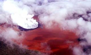
It looks like a giant cup of red wine or even blood.
Late last month villagers on Ambae, one of the chain of islands making up the Pacific nation of Vanuatu, made a startling discovery. The previously blue-green water in a three kilometre wide lake, perched at the top of a 1500 metre high active volcano, had suddenly turned bright red.
"It's quite red, like red wine," said Esline Garaebiti, the geo-hazards manager for Vanuatu's Department of Geology, Mines and Water Resources. But exactly why remains a mystery, she said, adding that water samples were being sent to Belgium and New Caledonia for analysis.
Lake Voui is believed to have been blasted into existence about 420 years ago when the volcano, Mount Manaro, exploded. It erupted again last November, forming a cone in the middle of the lake, before going quiet again in December. However, Manaro continues to smoke.
No one knows just when the lake turned red, but villagers, who consider it sacred, discovered the colour change on May 21 and reported their discovery three days later.
"They were surprised," said Ms Garaebiti. "This is not normal to them and they were wondering what was going on.
"We don't have any records of it turning red before, but there are legends, stories of the old people, of the water turning red, then black." According to the legends, having the water turning to "blood means war".
"Of course, the water is turning red due to some chemical reaction," said Ms Garaebiti, who noted that the lake's colour resembled oxidised iron, or rust.
Bernie Joyce, a vulcanologist at Melbourne University, said temperature changes or seismic events, such as earthquakes, caused lakes to change colour by disrupting layers of water containing different chemicals. "It can bring up stuff from below," said Professor Joyce, explaining that nutrients could trigger colourful algae blooms and minerals could reflect light in different ways.
South Australia's Blue Lake, a volcanic crater at Mount Gambier, was one such lake, undergoing an annual switch in summer from grey to blue.
But Professor Joyce said the sudden redness of the Vanuatu lake was interesting.
While volcanoes did spew out iron-rich ash, "oxidation requires oxygen", he said. "You don't get a lot of oxygen in a volcano."
He speculated that chlorine and sulfur from the volcano may have somehow reacted with iron in the lake, but the chemistry required, he conceded, was "all a bit tricky".
Hawaii
----------------------------------------
MAP1.9 2006/06/15 09:15:16 19.394 -155.282 2.6 8 km ( 5 mi) SW of Volcano, HI
MAP2.6 2006/06/15 17:38:02 19.830 -156.131 16.3 18 km ( 11 mi) NW of Kalaoa, HI
Peace to all.

posted by Unknown @ 10:55 AM
0 comments
![]()
![]()
