*For Monday, 9 October 2006.
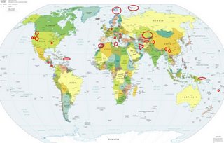
LEGEND for OVERVIEW: Size = My surety of area for quake.
Red Circle = Probable quake to STRONG quake.
Triangle = Very Strong/Stronger quake (Usually takes extra days).
Blue Circle, etc. = Uncertainty of symptom area for probable quake.

Places to watch.
Good luck to all.
For Monday, 9 October 2006.
---------------------------------------
Germany (Second day symptom - Strong)
---------------------------------------
(Nothing found)
El Salvador (12.57N 89.30W)
(Second day symptom but slightly
different area)
then
Costa Rica area (11.35N 85.52W)
---------------------------------------
06/10/09 12:02:42 11.38N 86.00W 34.3 2.5ML Rivas
06/10/09 08:59:36 12.21N 87.64W 11.3 2.9ML Frente a Corinto
06/10/09 06:33:57 11.07N 86.37W 14.8 3.0ML Frente a El Astillero
06/10/09 02:35:12 12.61N 87.53W 14.9 2.4ML Frente al Cosigüina
The New Madrid Fault
---------------------------------------
(Nothing found)
Romania (Strong)
---------------------------------------
07Oct2006 03:19:53.3 45.6N 26.4E140 ML=1.0 M ROM ROMANIA
(2 days early)
Kazakhstan/Krgyzstan area
(Third day symptom - Strong)
---------------------------------------
2006-10-09 10:52:05.0 48.40N 86.91E ML3.1 KAZAKHSTAN-XINJIANG BDR REG
Washington State (Non-specific
again - various areas)
---------------------------------------
1.3 2006/10/09 17:38:55 46.855 -121.612 1.0 32 km ( 20 mi) S of Greenwater, WA
2.1 2006/10/09 16:48:33 46.197 -122.188 0.2 1 km ( 0 mi) WSW of Mount St. Helens Volcano, WA
2.0 2006/10/09 15:52:25 46.196 -122.186 0.0 1 km ( 0 mi) SW of Mount St. Helens Volcano, WA
1.3 2006/10/09 10:38:55 46.855N 121.612W 1.0 32 km (20 mi) S of Greenwater, WA
2.1 2006/10/09 09:48:33 46.197N 122.188W 0.2 1 km ( 0 mi) WSW of Mount St. Helens Volcano, WA
2.0 2006/10/09 08:52:25 46.196N 122.186W 0.0 1 km ( 0 mi) SW of Mount St. Helens
1.7 2006/10/09 06:57:13 46.847 -121.585 5.5 33 km ( 20 mi) S of Greenwater, WA
2.2 2006/10/09 04:41:15 46.196 -122.188 0.0 1 km ( 0 mi) SW of Mount St. Helens Volcano, WA
1.2 2006/10/09 04:13:08 46.850 -121.607 7.4 32 km ( 20 mi) S of Greenwater, WA
Glen Ellen, California area
(38.392°N, 122.592°W)
http://www.blogger.com/img/gl.link.gifworldisround

---------------------------------------
2.0Q 2006/10/10 19:30:29 37.323 -122.102 0.7 0 km ( 0 mi) SSE of Quarry near Cupertino, CA(Probable quarry explosion)
Fiji Islands Region (17.44 S 178.72 W)
(Strong)
---------------------------------------
2006-10-08 14:46:53.7 23.50S 175.38W 10f mb5.3 TONGA ISLANDS REGION
2006-10-08 14:10:15.6 23.33S 175.53W 10 mb5.4 TONGA ISLANDS REGION
2006-10-08 13:50:23.3 23.55S 175.50W 10f Mw5.8 TONGA ISLANDS REGION
2006-10-08 18:54:55.1 23.57S 175.55W 10f mb5.4 TONGA ISLANDS REGION
2006-10-09 00:10:04.3 23.88S 174.79W 40 mb4.8 TONGA ISLANDS REGION
Central Italy/Ionian Sea
---------------------------------------
2006-10-08 19:21:59.0 42.86N 13.38E 9 ML2.5 CENTRAL ITALY
2006-10-09 11:36:54.0 41.83N 15.88E 23 ML3.0 SOUTHERN ITALY
The Geysers
---------------------------------------
1.6 2006/10/08 08:40:31 38.791 -122.753 1.9 5 km ( 3 mi) E of The Geysers, CA
1.4 2006/10/08 08:36:52 38.791 -122.752 1.7 5 km ( 3 mi) E of The Geysers, CA
1.2 2006/10/08 12:20:45 38.812 -122.815 2.0 2 km ( 1 mi) NNW of The Geysers, CA
1.2 2006/10/08 22:28:22 38.807 -122.792 2.5 2 km ( 1 mi) NE of The Geysers, CA
2.3 2006/10/09 01:30:12 38.794 -122.759 1.7 4 km ( 3 mi) E of The Geysers, CA
2.6 2006/10/09 06:04:33 38.803 -122.804 0.7 1 km ( 0 mi) NNE of The Geysers, CA
1.7 2006/10/09 15:10:16 38.815 -122.825 1.4 2 km ( 2 mi) NW of The Geysers, CA
1.5 2006/10/09 17:55:11 38.797 -122.767 1.1 3 km ( 2 mi) E of The Geysers, CA
Northcentral Iran (Second day
symptom - Very Strong)
---------------------------------------
2006-10-09 07:43:53.0 30.83N 56.74E 14 ML4.5 NORTHERN AND CENTRAL IRAN
Morocco area (Second day
symptom - Strong)
---------------------------------------
2006-10-09 03:11:22.8 36.54N 2.92W 2 ML2.6 STRAIT OF GIBRALTAR
Novaya Zemlya area (74.33 56.79)
(Strong)
---------------------------------------
NOVAYA ZEMLYA, RUSSIA
Origin time Lat Lon Azres Timres Wres Nphase Ntot Nsta Netmag
2006-280:13.19.09.0 73.12 57.94 8.01 0.93 2.93 3 3 1 2.60
NOVAYA ZEMLYA, RUSSIA
Origin time Lat Lon Azres Timres Wres Nphase Ntot Nsta Netmag
2006-280:21.42.08.0 77.95 68.44 10.69 0.69 3.36 3 4 2 2.49
NOVAYA ZEMLYA, RUSSIA
Origin time Lat Lon Azres Timres Wres Nphase Ntot Nsta Netmag
2006-281:07.48.19.0 71.02 51.67 15.45 1.13 5.00 3 3 2 2.31
NOVAYA ZEMLYA, RUSSIA
Origin time Lat Lon Azres Timres Wres Nphase Ntot Nsta Netmag
2006-281:13.35.55.0 71.85 58.88 15.12 0.67 4.45 3 3 3 2.27
YUNNAN, CHINA (23.44N 101.55E)
---------------------------------------
(Nothing found)
Svalbard, Norway Region (80.52 5.90)
(Strong)
---------------------------------------
HINLOPEN-OLGA STRAIT SVALBARD
Origin time Lat Lon Azres Timres Wres Nphase Ntot Nsta Netmag
2006-280:12.13.42.0 78.79 22.63 12.18 3.32 6.37 3 3 2 2.45
SVALBARD, NORWAY, REGION
Origin time Lat Lon Azres Timres Wres Nphase Ntot Nsta Netmag
2006-280:16.05.29.0 81.72 24.09 11.18 2.75 5.54 3 8 2 2.36
Malta/Central Mediterranean Sea area
(Strong)
---------------------------------------
2006-10-09 03:13:51.0 38.09N 15.57E 12 ML2.5 SICILY, ITALY
Xizang to Myanmar area (32.3N 95.1E)
(Strong)
---------------------------------------
(Nothing found)
SOUTHERN XINJIANG, CHINA
(39.23N 77.20E)
---------------------------------------
(Nothing found)
Utah/Nevada
---------------------------------------
1.1 2006/10/09 01:42:48 39.718 -110.773 9.2 8 km ( 5 mi) ENE of Helper, UT
1.2 2006/10/09 05:30:18 39.741 -110.736 0.1 12 km ( 7 mi) ENE of Helper, UT
1.2 2006/10/09 07:35:56 39.703 -110.709 7.1 13 km ( 8 mi) E of Helper, UT
1.5 2006/10/09 17:24:02 39.413 -111.222 2.2 24 km ( 15 mi) WNW of Huntington, UT
1.4 2006/10/09 18:38:17 38.605 -112.228 4.7 3 km ( 2 mi) SSW of Joseph, UT
1.6 2006/10/09 18:51:57 39.409 -111.229 2.0 24 km ( 15 mi) ESE of Spring City, UT
1.7 2006/10/09 19:15:49 38.560 -117.165 5.0 55 km ( 34 mi) N of Tonopah, NV
1.6 2006/10/09 21:15:08 39.416 -111.228 2.4 24 km ( 15 mi) ESE of Spring City, UT
1.4 2006/10/09 21:49:22 39.413 -111.225 2.3 24 km ( 15 mi) ESE of Spring City, UT
1.5 2006/10/09 22:11:21 38.609 -112.222 5.1 2 km ( 1 mi) S of Joseph, UT
Pakistan-Uzbekistan border area
(STRONG)
---------------------------------------
(Nothing found)
Puerto Rico/Virgin Islands
---------------------------------------
3.3 2006/10/09 23:20:25 18.770N -64.379W 58.1 8 km(5 mi)NW of Settlement, Anegada, British Virgin Islands
2.8 2006/10/09 19:29:20 18.373N -66.993W 133.6 4 km(3 mi)N of San Sebastián, PR
3.1 2006/10/09 19:07:47 17.954N -66.814W 8.1 4 km(3 mi)S of Indios, PR
2.3 2006/10/09 17:19:19 17.785N -65.984W 12.6 22 km(14 mi)S of Lamboglia, PR
3.7 2006/10/09 13:58:03 19.330N -63.873W 132.3 82 km(51 mi)NE of Settlement, Anegada, British Virgin Islands
3.6 2006/10/09 06:19:38 19.475N -65.222W 86.2 126 km(78 mi)NW of Settlement, Anegada, British Virgin Islands
3.4 2006/10/08 21:35:28 19.242N -64.285W 16.0 57 km(35 mi)N of Settlement, Anegada, British Virgin Islands
3.8 2006/10/08 09:17:52 18.093N -68.329W 113.5 71 km(44 mi)SE of Higüey, La Altagracia, Dominican Republic
3.4 2006/10/08 05:43:08 18.967N -67.861W 34.7 95 km(59 mi)NW of Rincón, PR
2.4 2006/10/08 02:44:45 17.919N -67.079W 8.3 7 km(4 mi)SSW of La Parguera, PR
New Ireland area (2.76 S 149.78 E)
---------------------------------------
2006-10-10 16:29:51.2 3.72S 135.56E 40 mb5.1 IRIAN JAYA, INDONESIA, REGION
Peace to all.

