*For Tuesday, 13 June 2006.
LEGEND for OVERVIEW: Size = My surety of area for quake.
Red Circle = Probable quake to STRONG quake.
Triangle = Very Strong or Stronger quake (And usually takes extra days).
Blue Circle, etc. = Uncertainty of symptom area for probable quake
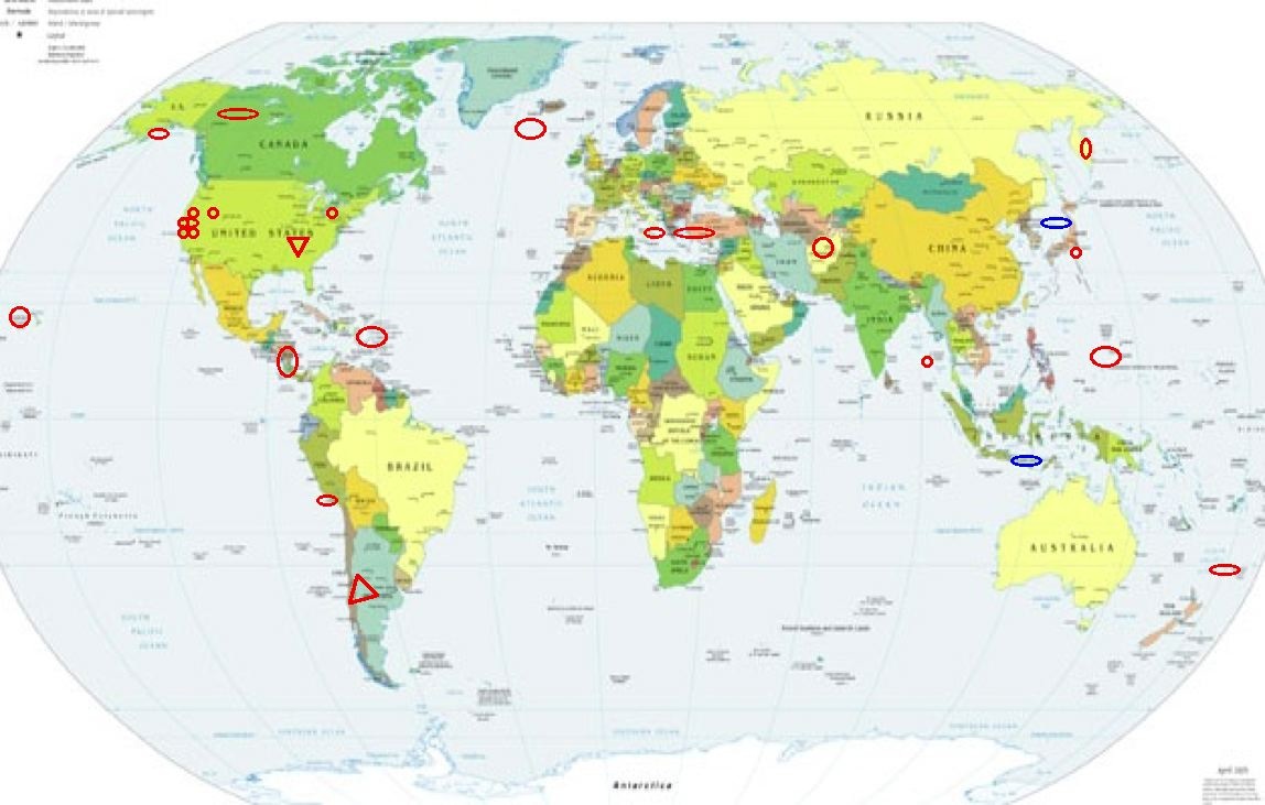
Places to watch.
Good luck to all.
For Tuesday, 13 June 2006.
----------------------------------------
Hawaii
----------------------------------------
MAP 2.0 2006/06/13 02:01:55 19.293 -155.274 7.4 18 km ( 11 mi) SSW of Volcano, HI
MAP 3.1 2006/06/13 07:18:03 19.625 -156.113 43.8 12 km ( 8 mi) W of Kailua, HI
MAP 2.4 2006/06/13 07:42:52 19.288 -155.798 10.3 20 km ( 12 mi) SSE of Honaunau-Napoopoo, HI
The New Madrid Fault (Third day symptom but not
as strong - Very Strong)
http://new-madrid-earthquake.com/>new-madrid-earthquake

----------------------------------------
(Still nothing found - this may take until 21st or 22nd.)
Utah (Second day of symptom - Strong)
----------------------------------------
MAP 1.7 2006/06/13 00:32:32 39.612 -110.398 1.3 7 km ( 4 mi) N of Sunnyside, UT
MAP 1.5 2006/06/13 02:38:57 39.611 -110.398 1.3 7 km ( 4 mi) N of Sunnyside, UT
MAP 1.6 2006/06/13 04:51:31 39.612 -110.395 1.1 7 km ( 4 mi) N of Sunnyside, UT
MAP 1.7 2006/06/13 10:31:17 39.737 -110.736 0.2 12 km ( 7 mi) ENE of Helper, UT
MAP 2.0 2006/06/13 15:54:03 41.916 -112.548 3.6 15 km ( 9 mi) ESE of Snowville, UT
MAP 1.1 2006/06/13 16:01:46 41.917 -112.547 2.7 15 km ( 9 mi) ESE of Snowville, UT
MAP 2.0 2006/06/13 19:19:10 39.613 -110.401 1.4 7 km ( 4 mi) N of Sunnyside, UT
MAP 1.4 2006/06/13 22:52:13 39.612 -110.396 1.3 7 km ( 4 mi) N of Sunnyside, UT
Nicaragua/Costa Rica area
----------------------------------------
06/06/13 00:45:28 12.31N 87.78W 12.5 3.1MC
06/06/13 01:27:55 12.07N 86.67W 98.2 2.6MC
06/06/13 02:51:07 11.64N 86.37W 62.6 2.6MC
06/06/13 05:09:46 13.78N 89.15W 15.0 3.9MC
06/06/13 06:59:56 11.88N 86.78W 0.0 2.7MC
06/06/13 12:22:17 12.63N 87.11W 19.9 2.0MC
06/06/13 17:18:57 12.81N 87.52W 41.3 2.5ML
Westcentral Argentina area (-35.127 -72.271) (VERY STRONG)
agoraimages

----------------------------------------
MAP 4.6 2006/06/13 14:53:58 -28.411 -67.307 124.3 LA RIOJA, ARGENTINA
Reykjanes Ridge
----------------------------------------
ICELAND REGION
Origin time Lat Lon Azres Timres Wres Nphase Ntot Nsta Netmag
2006-164:07.26.33.0 63.73 -10.69 18.70 0.20 4.87 2 3 1 2.30
Sicily, Italy/Ionian Sea
----------------------------------------
2006-06-13 04:34:21.0 38.92 N 15.38E 291 ML 3.6 SICILY, ITALY
13Jun2006 14:15:45.0 40.3N 19.8E 40 ML=4.0 M*ROM ALBANIA
South Shore Lake Erie (41.87N 80.87W)
(Second day of symptom - Strong)
----------------------------------------
map 2.3 2006/06/13 16:27:04 45.983N 74.874W 12.0 132 km (82 mi) N of Norfolk, NY
(More East and North than expected.)
Afghanistan (Probably swarm)
----------------------------------------
(Nothing found)
Possibly Irian Jaya, Indonesia (2.80 S 138.82 E)
----------------------------------------
2006-06-13 03:33:53 5.1 6.00 S 130.47 E Banda Sea
Possibly Sea of Japan (37.09 N 135.70 E)
----------------------------------------
2006-06-13 17:06:56 5.1 26.39 N 125.26 E Northeast of Taiwan
Puerto Rico/The Virgin Islands area
(Volcanic action at Soufrierre)
----------------------------------------
MAP 2.5 2006/06/13 07:39:15 17.936 -66.915 3.5 4 km ( 3 mi) S of Guánica, PR
MAP 2.7 2006/06/13 07:42:52 19.167 -67.604 21.4 94 km ( 58 mi) NNW of Cabán, PR
MAP 1.9 2006/06/13 10:38:15 17.900 -66.924 9.1 8 km ( 5 mi) S of Guánica, PR
MAP 2.6 2006/06/13 11:17:50 18.017 -65.456 17.0 9 km ( 6 mi) SSE of Esperanza, PR
Guam area (12.479 144.304) (Indication of depth - Strong)
----------------------------------------
(Nothing found - this may still be coming)
New Idria, California (36.393 -120.765)
----------------------------------------
MAP 1.1 2006/06/12 00:38:58 36.290 -120.586 12.7 16 km ( 10 mi) SSE of New Idria, CA
(This is one of those strange times when I feel a symptom for a mini-microquake and never feel a symptom for other large microquakes. I have no idea why.)
Honshu, Japan
----------------------------------------
12Jun2006 11:03:56.3 36.8N 142.6E 33 MS=4.0 M GSR OFF EAST COAST OF HONSHU,
Alaska Peninsula
----------------------------------------
MAP 5.1 2006/06/13 07:20:38 60.235 -148.711 50.0 KENAI PENINSULA, ALASKA
Coso Junction (36.040 -117.780)
----------------------------------------
MAP 1.5 2006/06/13 10:05:57 36.027 -117.886 5.3 6 km ( 4 mi) ESE of Coso Junction, CA
MAP 1.9 2006/06/13 10:54:31 36.022 -117.882 4.5 6 km ( 4 mi) ESE of Coso Junction, CA
MAP 1.0 2006/06/13 10:54:31 36.022 -117.885 3.8 6 km ( 4 mi) ESE of Coso Junction, CA
MAP 1.4 2006/06/14 02:25:16 35.971 -117.904 4.4 9 km ( 6 mi) SSE of Coso Junction, CA
Moraga, California (37.816 -122.070) (Strong)
----------------------------------------
MAP 1.5 2006/06/13 18:32:19 37.974 -122.431 0.0 8 km ( 5 mi) W of San Pablo, CA
MAP 1.7Q 2006/06/14 01:16:42 37.323 -122.106 0.2 0 km ( 0 mi) SSW of Quarry near Cupertino, CA(Probable quarry explosion)
MAP 1.3 2006/06/14 04:10:02 37.248 -121.635 2.2 13 km ( 8 mi) N of Morgan Hill, CA
MAP 4.7 2006/06/15 12:24:51 37.102 -121.492 3.1 10 km ( 6 mi) E of San Martin, CA
MAP 1.9 2006/06/15 12:32:49 37.093 -121.488 3.0 10 km ( 6 mi) E of San Martin, CA
MAP 1.6 2006/06/15 12:30:06 37.107 -121.484 3.8 11 km ( 7 mi) ENE of San Martin, CA
MAP 2.9 2006/06/15 12:27:16 37.109 -121.491 3.2 10 km ( 6 mi) ENE of San Martin, CA
MAP 1.3 2006/06/15 12:43:43 37.099 -121.492 0.0 10 km ( 6 mi) E of San Martin, CA
MAP 1.2 2006/06/15 12:42:33 37.085 -121.493 3.2 9 km ( 6 mi) E of San Martin, CA
MAP 2.0 2006/06/15 13:00:54 37.088 -121.491 0.7 10 km ( 6 mi) E of San Martin, CA
MAP 2.1 2006/06/15 14:42:21 37.104 -121.490 2.7 10 km ( 6 mi) E of San Martin, CA
(2 extra days - this swarm is probably the spikes I felt in my right elbow. A little closer to pinpointing the areas on my elbow.)
Near the Coast of Peru (16.51 S 73.65 W)
----------------------------------------
Mapa 13/06/2006 12:51:9 -26.478 -70.472 53.2 4.2 Ml GUC 25 km al SE de Chañaral
(Coast of Chile - off.)
Greece/Turkey area
----------------------------------------
MAP 2.2 2006/06/13 04:57:37 35.463 -120.086 9.8 15 km ( 9 mi) NNW of Simmler, CA
Cambria, California (35.641 -121.076)
----------------------------------------
MAP 2.2 2006/06/13 04:57:37 35.463 -120.086 9.8 15 km ( 9 mi) NNW of Simmler, CA
Kermadec Island
----------------------------------------
2006-06-14 20:33:48 5.5 36.99 S 179.66 W East of North Island, N.Z.
Andaman Islands (10.93 N 94.37 E) (Strong)
----------------------------------------
(Symptoms felt for 12, 13 and 14 June and posted on 14th.)
The Geysers
----------------------------------------
MAP 1.5 2006/06/13 04:41:56 38.808 -122.793 1.1 2 km ( 1 mi) NE of The Geysers, CA
MAP 1.9 2006/06/14 00:13:33 38.780 -122.761 0.7 4 km ( 3 mi) ESE of The Geysers, CA
MAP 1.1 2006/06/14 03:48:22 38.825 -122.782 1.6 4 km ( 2 mi) NE of The Geysers, CA
MAP 1.3 2006/06/14 15:34:30 38.833 -122.800 1.3 4 km ( 2 mi) N of The Geysers, CA
MAP 1.8 2006/06/14 18:15:00 38.801 -122.782 2.9 2 km ( 1 mi) E of The Geysers, CA
MAP 1.6 2006/06/14 22:28:09 38.797 -122.793 5.8 1 km ( 1 mi) E of The Geysers, CA
Yukon/Northwest Territories, Canada
----------------------------------------
2006/06/14 17:54:48 65.24N 133.21W 1.0* 3.1ML 250 km SE of Ft. McPherson,NT
Kamchatka
----------------------------------------
(I will include Northern Kurils when this symptom comes again.)
Peace to all.

posted by Unknown @ 2:53 PM
0 comments
![]()
![]()
