*For Wednesday, 11 January 2006.
LEGEND for OVERVIEW:
Size = My surety of area for quake.
Red Circle = Probable quake to STRONG quake.
Red Triangle = Very Strong or Stronger quake (And usually takes extra days).
Blue Circle = Uncertainty of symptom area for probable quake.

Places to watch.
Good luck to all.
For Wednesday, 11 January 2006.
----------------------------------------
Azores area (VERY STRONG and may take extra days)
----------------------------------------
2006/01/11 01:16:32.3 37.35 N 13.83 W mb3.5 NORTH ATLANTIC OCEAN
2006/01/11 01:48:43.3 37.39 N 13.63 W 125 mb4.4 NORTH ATLANTIC OCEAN
2006/01/11 12:59:18.1 37.34 N 13.95 W mb4.3 NORTH ATLANTIC OCEAN
South Sandwich Islands and South of (EXTREMELY STRONG and may take extra days)
South Sandwich
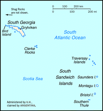
----------------------------------------
MAP 4.3 2006/01/11 03:02:41 -59.337 -26.288 135.2 SOUTH SANDWICH ISLANDS REGION
(Symptoms indicated something much bigger - may still be coming.)
Possibly the Equator area of the Atlantic Ocean (Not sure of this symptom yet.)
----------------------------------------
(Nothing found)
The Moluccas area (STRONG)
----------------------------------------
11Jan2006 18:53:36.6 4.1S 128.8E 33 MS=4.5 M GSR BANDA SEA 1957
Kalaoa, Hawaii area (19.676 -156.429) (EXTREMELY STRONG - may take extra days)
Kalaoa, Hawaii
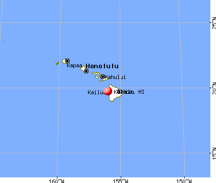
----------------------------------------
map 2.4 2006/01/10 05:25:02 19.468 -155.937 13.7 5 km ( 3 mi) SW of Captain Cook, HI
map 1.8 2006/01/11 02:25:47 19.407 -155.244 3.6 5 km ( 3 mi) S of Volcano, HI
map 2.0 2006/01/11 18:38:44 19.398 -155.056 3.9 11 km ( 7 mi) SE of Fern Forest, HI
map 2.5 2006/01/12 14:29:25 20.329 -155.465 2.4 26 km ( 16 mi) NNE of Kukuihaele, HI
(This may still have quakes coming)
Iceland area
----------------------------------------
2006/01/12 01:51:34.3 51.81 N 31.57 W 10G M 4.6 NORTHERN MID-ATLANTIC RIDGE
2006/01/13 15:19:29.7 66.23 N 17.12 W 7 ML3.6 ICELAND REGION
(2 extra days)
Utah
----------------------------------------
map 1.5 2006/01/11 13:33:05 39.674 -110.522 1.0 17 km ( 11 mi) NW of Sunnyside, UT
map 1.3 2006/01/11 18:01:34 41.090 -111.555 2.7 9 km ( 6 mi) NNW of Henefer, UT
map 1.6 2006/01/11 18:11:58 40.639 -111.356 5.6 7 km ( 4 mi) W of Kamas, UT
map 1.1 2006/01/11 18:22:35 40.705 -111.402 1.5 10 km ( 6 mi) ENE of Park City, UT
map 1.3 2006/01/11 22:57:46 39.674 -110.525 1.3 17 km ( 11 mi) NNW of East Carbon, UT
Alaska Peninsula (Strong - possibly deep)
----------------------------------------
map 3.8 2006/01/10 03:24:53 56.116 -159.639 200.0 ALASKA PENINSULA
(Definitely deep.)
map 3.7 2006/01/10 23:38:05 54.834 -161.159 30.0 ALASKA PENINSULA
Cupertino Quarry (.37.324 -122.105)
----------------------------------------
map 1.4 2006/01/12 00:02:10 37.950 -122.090 9.0 2 km ( 1 mi) W of Pleasant Hill, CA
Petrolia
----------------------------------------
2006-01-11 10:02:31 5.2 41.90 N 129.78 W Off Coast of N. California
Bloomingdale, New Jersey (41.014 -74.315)
----------------------------------------
MAP 3.4 2006/01/09 15:35:39 44.979 -73.895 5.0 16 km ( 10 mi) ENE of Chateaugay, NY
(Maybe this quake but would be 2 days early)
Central South Atlantic (Various areas)
----------------------------------------
(Nothing found)
Kyushu to Ryukyu, Japan and then Honshu
----------------------------------------
2006-01-11 21:45:44 5.1 30.45 N 138.54 E Southeast of Honshu, Japan
Northwestern Siberia (Medium)
----------------------------------------
(Nothing found)
Mt. Hood area
----------------------------------------
(Nothing found)
Northern Xinjiang, China (43.79 N 83.82 E) (Medium)
----------------------------------------
2006/01/12 01:05:37.2 23.44 N 101.55 E 80 mb4.8 YUNNAN, CHINA ??
(Not very close.)
Northern Sumatra then Bay of Bengal area
----------------------------------------
2006/01/11 00:46:48.1 0.34 N 98.06 E 80 mb5.2 NORTHERN SUMATERA, INDONESIA
2006/01/11 07:34:56.0 0.10 N 97.75 E 30 mb5.1 NORTHERN SUMATERA, INDONESIA
2006/01/12 13:36:07.0 1.17 N 96.80 E 10 mb5.2 OFF W. CST OF NORTHERN SUMATERA
(Nothing found for Bay of Bengal)
Gulf of California area (Very Strong)
----------------------------------------
map 2.4 2006/01/11 23:47:53 31.839 -116.272 6.0 31 km ( 19 mi) ENE of Maneadero, Mexico
Kazakhstan (MEDIUM)
----------------------------------------
2006/01/11 05:15:34.0 43.22 N 63.68 E ML3.1 WESTERN KAZAKHSTAN
Possibly Lake Erie (MEDIUM)
----------------------------------------
map 2.4 2006/01/13 15:32:17 41.657 -81.430 6.7 1 km ( 0 mi) SE of Eastlake, OH
(2 days extra)
Algeria (Medium)
----------------------------------------
(Nothing found)
Peace to all.

posted by Unknown @ 3:13 PM
0 comments
![]()
![]()
