*For Monday, 16 October 2006.
LEGEND for OVERVIEW: Size = My surety of area for quake.
Red Circle = Probable quake to STRONG quake.
Triangle = Very Strong/Stronger quake (Usually takes extra days).
Blue Circle, etc. = Uncertainty of symptom area for probable quake.
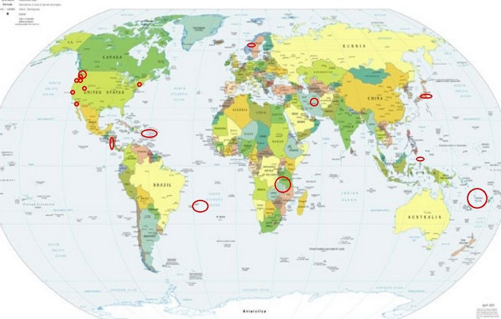
Places to watch.
Good luck to all.
For Monday, 16 October 2006.
---------------------------------------
REPUBLIC OF SOUTH AFRICA (23.4S 30.6E)
---------------------------------------
(Nothing found)
Mt. Hood area (Strong)
and Oregon (45.348N 122.016W)
then Mt. Rainier area (Strong)
and other areas of Washington State
---------------------------------------
1.2 2006/10/16 21:28:16 48.744N 122.319W 14.6 3 km(2 mi) NNE of Sudden Valley, WA
1.4 2006/10/16 21:12:08 48.736N 122.320W 14.7 2 km(1 mi) NE of Sudden Valley, WA
1.4 2006/10/16 20:33:34 48.738N 122.312W 8.6 3 km(2 mi) NE of Sudden Valley, WA
2.1 2006/10/16 19:57:32 46.194N 122.192W 0.0 1 km(1 mi) SW of Mount St. Helens Volcano, WA
1.7 2006/10/16 18:09:01 48.743N 122.321W 14.5 3 km(2 mi) NNE of Sudden Valley, WA
1.7 2006/10/16 16:37:44 46.713N 121.883W 5.2 11 km(7 mi) ESE of Ashford, WA
1.7 2006/10/16 13:18:17 46.194N 122.198W 0.8 2 km(1 mi) WSW of Mount St. Helens Volcano, WA
2.9 2006/10/16 13:15:54 46.172N 122.177W 0.0 3 km(2 mi) S of Mount St. Helens Volcano, WA
2.0 2006/10/16 06:28:52 46.194N 122.189W 0.0 1 km(1 mi) SW of Mount St. Helens Volcano, WA
2.4 2006/10/17 22:01:04 46.195N 122.193W 0.3 1 km(1 mi) WSW of Mount St. Helens Volcano, WA
1.7 2006/10/17 12:50:05 46.195N 122.191W 0.0 1 km(1 mi) SW of Mount St. Helens Volcano, WA
2.3 2006/10/17 08:51:46 46.196N 122.196W 0.0 1 km(1 mi) WSW of Mount St. Helens Volcano, WA
1.2 2006/10/17 07:19:28 46.194N 122.195W 1.0 1 km(1 mi) WSW of Mount St. Helens Volcano, WA
1.5 2006/10/17 00:13:47 46.194N 122.195W 0.0 1 km(1 mi) WSW of Mount St. Helens Volcano, WA
Guadalupe Victoria, Mexico (32.338 -115.251)
---------------------------------------
2.4 2006/10/15 06:12:44 32.203 -115.192 3.2 12 km(8 mi)SW of Guadalupe Victoria, Mexico
2.8 2006/10/15 14:37:23 32.275 -115.115 4.4 2 km(1 mi)SSW of Guadalupe Victoria, Mexico
2.7 2006/10/16 05:40:56 32.373 -115.023 0.0 12 km(8 mi)NE of Guadalupe Victoria, Mexico
3.3 2006/10/17 15:32:33 32.331 -115.104 3.5 5 km(3 mi)N of Guadalupe Victoria, Mexico
New York (44.514N, 74.527W)
---------------------------------------
2006/10/15 04:25:35 44.20N 68.19W 5.0* 2.0MN Maine
2006/10/17 05:39:03 44.33N 68.16W 5.0* 1.8MN Near Bar Harbor,Maine
Halmahera, Indonesia (1.29N 128.23E)
(Medium)
---------------------------------------
2006-10-18 12:10:01.4 1.76N 127.49E 127 M4.9 HALMAHERA, INDONESIA
(2 extra days)
Norway (22.48 6.33) (2 different symptoms -
Strong)
---------------------------------------
HARDANGER NORWAY
Origin time Lat Lon Azres Timres Wres Nphase Ntot Nsta Netmag
2006-288:14.41.20.0 59.76 5.22 2.28 0.43 1.00 3 3 3 2.66
CENTRAL FINNMARK NORWAY
Origin time Lat Lon Azres Timres Wres Nphase Ntot Nsta Netmag
2006-289:05.46.56.0 70.42 22.82 14.05 0.16 3.67 2 2 1 2.29
TROMS NORWAY
Origin time Lat Lon Azres Timres Wres Nphase Ntot Nsta Netmag
2006-289:06.28.24.0 69.53 17.73 1.34 0.28 0.61 2 3 2 2.83
(My coordinates on my list are obviously transposed wrongly.)
Loyalty Islands area (20.30S 168.80E)
---------------------------------------
2006-10-15 15:39:17.4 21.88S 170.16E 33 mb5.0 SE.OF LOYALTY ISLANDS
2006-10-17 01:59:11.0 17.39S 167.89E 33 mb5.2 VANUATU ISLANDS
2006-10-17 02:36:29.8 14.96S 172.33E 550f mb5.3 VANUATU ISLANDS REGION
Utah
---------------------------------------
06/10/16 08:09:05 40.88N 110.93W 9.0 1.1 24.6 mi NE of Kamas
06/10/16 21:46:51 39.71N 110.77W 7.8 1.1 4.7 mi NE of Helper
06/10/16 23:38:37 39.72N 110.75W 0.5 1.4 6.1 mi NE of Helper
06/10/17 09:00:21 38.99N 111.32W 0.5 2.0 6.3 mi NW of Emery
06/10/17 10:48:50 39.72N 110.76W 4.8 1.1 5.8 mi NE of Helper
06/10/17 11:42:22 37.70N 112.93W 7.0 1.4 7.0 mi ESE of Enoch
06/10/17 21:28:27 39.00N 111.33W 12.3 1.6 6.8 mi NW of Emery
06/10/17 23:24:02 39.00N 111.33W 12.0 1.9 6.9 mi NW of Emery
06/10/17 23:26:25 39.42N 111.23W 9.5 1.7 14.6 mi E of Spring City
06/10/18 03:28:42 39.00N 111.33W 9.3 2.1 6.8 mi NW of Emery
06/10/18 03:34:46 39.46N 111.21W 3.1 1.6 14.4 mi ESE of Mount Pleasant
06/10/18 03:37:40 39.00N 111.33W 11.9 2.1 6.9 mi NW of Emery
06/10/18 03:40:37 39.00N 111.32W 13.5 1.6 6.9 mi NW of Emery
06/10/18 04:03:15 39.00N 111.34W 11.8 1.7 7.4 mi NW of Emery
06/10/18 04:04:17 38.99N 111.30W 14.4 1.6 5.6 mi NW of Emery
06/10/18 04:31:01 38.13N 112.80W 5.5 1.1 9.2 mi ESE of Minersville
06/10/18 04:31:10 39.00N 111.33W 7.0 1.6 7.0 mi NW of Emery
06/10/18 05:59:35 39.67N 110.48W 4.0 1.1 9.2 mi NNW of E. Carbon City
06/10/18 06:27:02 39.41N 111.22W 2.2 1.5 15.3 mi WNW of Huntington
06/10/18 06:35:20 39.41N 111.23W 2.4 1.6 15.2 mi E of Spring City
06/10/18 12:01:46 39.00N 111.33W 12.3 1.7 6.8 mi NW of Emery
06/10/18 18:06:22 39.46N 111.21W 3.6 2.0 14.2 mi ESE of Mount Pleasant
06/10/18 19:41:00 39.42N 111.23W 2.9 1.7 15.1 mi E of Spring City
(2 extra days)
Honshu, Japan and West of (2 different
symptoms - Strong)
---------------------------------------
(Nothing found)
Nicaragua/Costa Rica
---------------------------------------
06/10/16 21:12:03 12.54N 87.66W 14.3 3.1MC Frente al Cosigüina
06/10/16 14:09:35 10.61N 86.12W 5.3 3.8ML Oceano Pacífico de Nicaragua
06/10/16 12:12:10 11.48N 87.00W 21.5 3.4ML Frente a Masachapa
06/10/16 11:14:39 11.77N 87.22W 12.7 3.2ML Frente a Puerto Sandino
06/10/16 05:48:37 12.47N 87.79W 20.1 2.9ML Frente al Cosigüina
06/10/16 05:04:52 12.43N 87.68W 1.0 2.0ML Frente al Cosigüina
06/10/17 10:16:39 10.93N 86.23W 1.0 2.7ML Frente a San Juan del Sur
06/10/17 08:08:08 11.67N 87.68W 1.0 2.6ML Frente a Poneloya
06/10/17 07:43:59 11.72N 86.58W 68.6 2.7MC Frente a Masachapa
The Virgin Islands then Puerto Rico
(2 different symptoms - Strong)
---------------------------------------
3.5 2006/10/16 22:27:48 18.915N -64.058W 70.6 34 km (21 mi) NE of Settlement, Anegada, British Virgin Islands
3.3 2006/10/16 21:31:52 18.996N -64.787W 44.8 57 km (36 mi) WNW of Settlement, Anegada, British Virgin Islands
2.2 2006/10/16 03:44:55 18.169N -67.034W 24.2 6 km ( 4 mi) WSW of Maricao, PR
The Parkfield Fault/Parkfield area
---------------------------------------
1.9 2006/10/16 00:08:43 36.036 -120.594 3.8 21 km ( 13 mi) NW of Parkfield, CA
1.2 2006/10/16 04:43:21 35.809 -120.348 6.0 13 km ( 8 mi) SE of Parkfield, CA
1.9 2006/10/16 05:28:38 35.559 -120.731 1.2 2 km ( 1 mi) WNW of Templeton, CA
2.0 2006/10/16 12:18:46 35.510 -120.823 7.6 10 km ( 6 mi) NE of Cayucos, CA
2.1 2006/10/16 13:54:20 36.591 -121.197 6.9 8 km ( 5 mi) NW of Pinnacles, CA
Northcentral Iran (MEDIUM)
---------------------------------------
2006-10-16 03:49:38.0 27.88N 54.33E 14 M3.1 SOUTHERN IRAN
(Not Northcentral)
Trinidade Island area (21.0S 30.0W)
---------------------------------------
(Nothing found)
Peace to all.

posted by Unknown @ 3:38 PM
0 comments
![]()
![]()
