*For Monday, 2 January 2006.
Places to watch.
Good luck to all.
For Monday, 2 January 2006.
----------------------------------------
Hokkaido and Kurils (Strong for both)
----------------------------------------
2006/01/03 12:26:05.7 42.31 N 142.24 E 49 mb5.1 HOKKAIDO, JAPAN, REGION
Algeria (Strong)
----------------------------------------
2006/01/03 17:58:42.5 36.91 N 4.18 E 20 mb4.0 NORTHERN ALGERIA
2006/01/04 01:51:11.6 36.81 N 1.50 E 1 mb3.0 NORTHERN ALGERIA
(2 extra days)
Aegean Sea/Turkey (Strong for both)
----------------------------------------
2006/01/02 07:06:38.8 36.11 N 27.54 E 28 MD3.1 DODECANESE ISLANDS, GREECE
2006/01/02 10:58:15.1 38.97 N 23.31 E 5G ML2.7 GREECE
2006/01/02 11:55:03.8 38.11 N 26.60 E 12 MD2.9 AEGEAN SEA
2006/01/02 12:30:29.2 35.70 N 27.74 E 18 MD3.4 DODECANESE ISLANDS, GREECE
2006/01/02 17:57:43.5 37.86 N 29.25 E 5 MD3.2 TURKEY
2006/01/02 18:49:22.4 38.23 N 26.57 E 12 MD3.0 AEGEAN SEA
2006/01/02 21:20:02.4 39.11 N 21.69 E 7G ML2.8 GREECE
2006/01/02 22:29:23.2 37.14 N 29.75 E 31 MD3.1 TURKEY
2006/01/02 23:45:44.2 38.83 N 27.80 E 5 MD3.0 TURKEY
Puerto Rico and into Atlantic Ocean/possibly Canary Islands (New symptom for old area - a jolt - EXTREMELY STRONG.)...Left forearm just above elbow (Puerto Rico area) - top inside a jolt 6:02am then more jolts at 6:35am then jolts closer to middle that made fingers contract (making it non-specific but EXTREME) and off and on more than 6 times at 6:39am and then 10 more jolts at 6:42am. Then left forearm middle/inside - Canary Islands area) light jolts of muscle that pulls the middle fingers down off and on during morning 11:53am.
http://www.blogger.com/img/gl.link.gifCanary Islands Threat

----------------------------------------
map 2.7 2006/01/02 00:04:30 18.794 -66.372 51.0 36 km ( 22 mi) N of Breñas, PR
map 2.8 2006/01/02 01:28:00 17.962 -66.878 4.6 2 km ( 1 mi) SSE of María Antonia, PR
map 1.7 2006/01/02 01:29:55 17.948 -66.894 8.4 3 km ( 2 mi) S of María Antonia, PR
map 2.1 2006/01/02 06:28:03 18.098 -67.207 25.5 3 km ( 2 mi) NW of Puerto Real, PR
map 1.9 2006/01/02 08:32:58 17.954 -66.905 8.4 3 km ( 2 mi) SE of Guánica, PR
2006/01/02 21:33:23.6 24.55 N 45.02 W 33 mb5.0 NORTHERN MID-ATLANTIC RIDGE
2006/01/02 06:10:52.4 61.05 S 21.82 W 33 Mw7.3 SOUTHWESTERN ATLANTIC OCEAN ???
(This jolting of my left forearm seems to have the intensity of the Southern Atlantic earthquake but I did not get the symptom for the Southern Atlantic as hard as this Northern Atlantic Ocean symptom. I am thinking that something is still about to hit in the Northern Atlantic area which may be as big or bigger than the 7.3 quake and might be affecting more civilization. Please be on alert until after the 7th or 8th of January.)
Utah/Nevada (Medium)
----------------------------------------
map 1.5 2006/01/02 00:52:40 38.714 -118.917 5.0 18 km ( 11 mi) NNE of Wichman, NV
map 2.7 2006/01/02 06:29:12 38.549 -115.004 15.0 22 km ( 14 mi) NE of Hot Creek, NV
map 1.2 2006/01/02 13:11:33 39.704 -110.594 1.2 22 km ( 13 mi) ENE of Price, UT
map 1.4 2006/01/03 06:01:18 39.737 -110.729 0.5 12 km ( 8 mi) ENE of Helper, UT
map 1.2 2006/01/03 13:48:07 39.291 -111.974 6.9 12 km ( 8 mi) ENE of Scipio, UT
map 1.4 2006/01/03 16:10:22 39.693 -110.459 6.8 16 km ( 10 mi) NNW of Sunnyside, UT
map 1.4 2006/01/03 17:10:43 39.730 -110.729 0.5 12 km ( 7 mi) ENE of Helper, UT
map 1.6 2006/01/03 23:34:46 38.936 -112.929 2.2 45 km ( 28 mi) WNW of Kanosh, UT
Ludlow/Yucca Valley area
----------------------------------------
(Nothing found)
South Sandwich Islands (Medium)
----------------------------------------
2006/01/02 06:10:52.4 61.05 S 21.82 W 33 Mw7.3 SOUTHWESTERN ATLANTIC OCEAN ???
Hawaii area/possibly Waimea (Medium)
----------------------------------------
map 2.8 2006/01/02 19:43:12 19.346 -155.084 2.9 15 km ( 9 mi) SSE of Fern Forest, HI
map 2.8 2006/01/02 19:43:11 19.346 -155.072 8.4 15 km ( 10 mi) SSE of Fern Forest, HI
map 2.6 2006/01/02 20:57:10 20.258 -155.133 1.9 32 km ( 20 mi) NNE of Laupahoehoe, HI
MAP 3.4 2006/01/02 22:20:59 19.140 -155.564 14.4 9 km ( 5 mi) NNE of Naalehu, HI
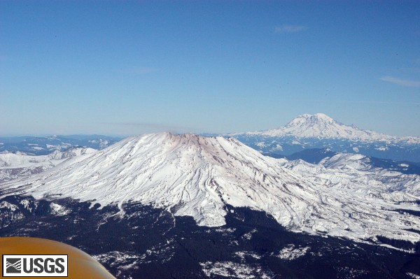
Kendall, Washington area then Mt. St. Helen's (Medium for Kendall. ERUPTION and STRONG for Mt. St. Helen's - I had 2 right neck side middle sparkle pinches that caused goose bumps.)
Thumbnail Photos
----------------------------------------
map 2.3 2006/01/03 09:38:18 46.197 -122.192 0.0 1 km ( 1 mi) WSW of Mount St. Helens Volcano, WA
map 1.5 2006/01/03 12:50:23 46.194 -122.190 0.0 1 km ( 1 mi) SW of Mount St. Helens Volcano, WA
map 2.2 2006/01/02 15:19:54 46.198 -122.190 0.0 1 km ( 1 mi) WSW of Mount St. Helens Volcano, WA
(Found nothing about eruption. Might still be coming as late as the 6th of January.)
Kyushu to Bonnin (Medium)
----------------------------------------
02Jan2006 14:28:15.4 26.8N 140.9E 33 mb=4.8 M GSR BONIN ISLANDS REGION 1526
Ukraine-Moldova-Southwestern (STRONG)
----------------------------------------
(Nothing found)
Sulawessi/Moluccas (Medium)
----------------------------------------
2006/01/01 19:32:24.5 7.01 S 129.26 E 30 mb5.3 BANDA SEA
Los Lagos, Chile area (-42.811 -74.175) (Very Strong)
----------------------------------------
MAP 4.5 2006/01/01 10:36:29 -32.467 -71.549 61.6 OFFSHORE VALPARAISO, CHILE
Peace to all.

posted by Unknown @ 1:16 PM
0 comments
![]()
![]()
