*For Sunday, 12 February 2006.
LEGEND for OVERVIEW:
Size = My surety of area for quake.
Red Circle = Probable quake to STRONG quake.
Triangle = Very Strong or Stronger quake (And usually takes extra days).
Blue Circle, etc. = Uncertainty of symptom area for probable quake.
Places to watch.
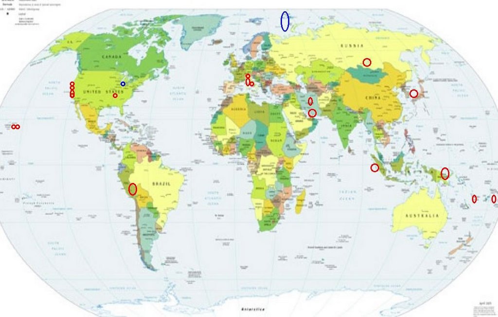
Good luck to all.
For Sunday, 12 February 2006.
----------------------------------------
Lake Baykal, Russia area and North of (55.55 N 110.54 E) then Sea of Japan area (37.09N 135.70E) (MEDIUM for each area)
----------------------------------------
2006-02-11 14:39:51.6 55.23N 110.31E 15 Ms4.0 LAKE BAYKAL, RUSSIA, REGION
2006-02-12 15:11:37.4 41.22N 142.64E 200 mb4.3 HOKKAIDO, JAPAN, REGION
Southern Iran (26.4N 54.4E) then Northcentral Iran (34.63 N 53.19 E)
----------------------------------------
(Nothing found)
Between Pinnacles and Parkfield
----------------------------------------
MAP 1.2 2006/02/12 06:59:13 36.831 -121.349 5.3 5 km ( 3 mi) ESE of Hollister, CA
MAP 1.2 2006/02/12 09:12:29 36.039 -120.540 0.0 18 km ( 11 mi) NNW of Parkfield, CA
The Geysers ( 38.826 -122.795) (Medium)
----------------------------------------
MAP 1.9 2006/02/11 01:50:26 38.816 -122.784 2.4 3 km ( 2 mi) NE of The Geysers, CA
MAP 1.3 2006/02/11 22:07:02 38.830 -122.874 1.3 7 km ( 4 mi) WNW of The Geysers, CA
MAP 2.3 2006/02/12 05:52:29 38.832 -122.806 2.6 4 km ( 2 mi) N of The Geysers, CA
Kilauea, Hawaii (19.398N 155.254W) then Fern Forest area (19.318 -155.120) (Medium for both areas)
----------------------------------------
MAP 2.3 2006/02/12 07:49:49 19.384 -155.242 2.2 7 km ( 5 mi) S of Volcano, HI
MAP 2.1 2006/02/12 08:30:48 19.388 -155.239 4.3 7 km ( 4 mi) S of Volcano, HI
MAP 2.5 2006/02/12 19:19:04 19.348 -155.068 7.6 15 km ( 9 mi) SSE of Fern Forest, HI
MAP 2.4 2006/02/12 19:41:06 19.391 -155.243 4.0 7 km ( 4 mi) S of Volcano, HI
MAP 2.3 2006/02/12 22:03:51 19.395 -155.249 3.4 6 km ( 4 mi) SSW of Volcano, HI
MAP 1.8 2006/02/12 22:54:49 19.391 -155.248 3.5 7 km ( 4 mi) S of Volcano, HI
Fiji Islands Region (16.26 S 176.59 W) (Strong)
----------------------------------------
2006-02-11 14:49:40 5.0 21.77 S 176.85 W Fiji Islands Region
Southern Peru area (16.91S 70.50W) (STRONG)
----------------------------------------
MAP 4.0 2006/02/11 04:40:08 -24.137 -67.032 170.1 SALTA, ARGENTINA
MAP 4.8 2006/02/11 11:49:40 -32.347 -67.065 36.3 SAN LUIS, ARGENTINA
(More South than expected.)
Nias Region, Indonesia (1.919 96.625) (Strong)
----------------------------------------
2006-02-11 04:57:52.1 3.50N 126.88E 60 mb=5.5 TALAUD ISLANDS, INDONESIA
11Feb2006 08:48:07.0 9.5S 117.1E 33 mb=4.3 M GSR SUMBAWA REGION, INDONESIA 1108
Central Italy then Northern Italy then Monaco area (MEDIUM for Central Italy and Northern Italy - STRONG for Monaco area)
----------------------------------------
2006-02-13 23:03:07.0 42.59N 13.26E 7 ML3.0 CENTRAL ITALY
(More may still be coming)
Possibly Franz Josef/Barents Sea area (Strong)
----------------------------------------
10Feb2006 13:22:20.9 70.9N 14.5W 33 mb=4.9 M*GSR JAN MAYEN ISLAND REGION
The New Madrid Fault/Missouri then possibly Chicago, Illinois area (New symptom) (Medium for both areas)
----------------------------------------
map 1.6 2006/02/12 11:35:16 36.270N 89.770W 17.7 4 km ( 3 mi) NNW of Hayti, MO
(Nothing for Chicago and expected more for Missouri)
North of Eastern Papua New Guinea (5.18 S 145.32 E) (Medium)
----------------------------------------
2006-02-12 06:02:22.9 9.56S 151.18E 10 mb4.9 D'ENTRECASTEAUX ISLANDS
Vanuatu (15S 167E) (Medium)
----------------------------------------
10Feb2006 16:09:24.6 15.2S 167.8E 50 mb=5.2 M*GSR VANUATU ISLANDS
(2 days early)
San Francisco area
----------------------------------------
MAP 1.3 2006/02/12 04:21:31 36.854 -121.581 6.6 4 km ( 3 mi) WNW of San Juan Bautista, CA
Paso Robles to Lake Nacimiento, California (35.643 -120.832) (This had volcanic heat - Strong)
----------------------------------------
MAP 2.6 2006/02/12 13:45:19 35.715 -121.114 0.1 10 km ( 7 mi) NE of San Simeon, CA
MAP 2.2 2006/02/12 23:08:19 35.705 -121.019 5.3 13 km ( 8 mi) WSW of Lake Nacimiento, CA
Peace to all.

posted by Unknown @ 1:09 PM
0 comments
![]()
![]()
