*For Friday, 1 September 2006.
LEGEND for OVERVIEW: Size = My surety of area for quake.
Red Circle = Probable quake to STRONG quake.
Triangle = Very Strong/Stronger quake (Usually takes extra days).
Blue Circle, etc. = Uncertainty of symptom area for probable quake.
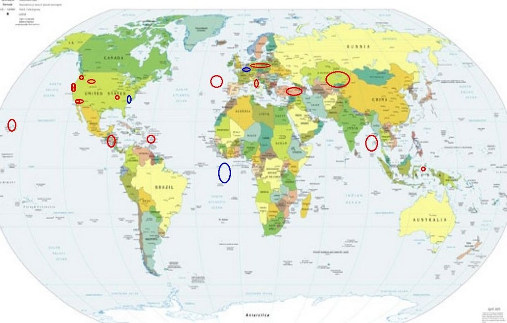
Places to watch.
Good luck to all.
For Friday, 1 September 2006.
---------------------------------------
Nicaragua/Guatamala area (STRONG)
---------------------------------------
06/08/31 23:28:26 12.49N 86.71W 1.0 1.0ML Cerca del Volcan Cerro Negro
06/08/31 22:02:25 12.40N 87.82W 49.2 3.4ML Frente al Cosigüina
06/08/31 19:05:15 12.44N 87.85W 17.1 3.1ML Frente al Cosigüina
06/08/31 16:32:32 11.35N 85.80W 86.3 2.2ML Rivas
06/08/31 12:57:34 12.19N 87.67W 7.9 2.3ML Frente a Corinto
06/08/31 10:19:00 11.15N 85.64W 224.6 3.8MC Rivas
06/08/31 09:36:48 11.35N 86.61W 12.1 2.7MC Frente a La Boquita y Casares
06/08/31 05:37:34 12.83N 88.83W 47.9 3.2MC Frente a El Salvador
06/08/31 00:37:18 13.23N 88.96W 1.0 3.6MC Frente a El Salvador
06/08/31 00:37:15 13.26N 89.47W 48.8 4.5ML Frente a El Salvador
06/09/01 16:28:17 12.76N 87.10W 16.9 2.8ML Cerca del Volcan San Cristóba
06/09/01 14:39:37 12.44N 87.60W 59.7 2.7ML Frente al Cosigüina
06/09/01 11:45:31 7.71N 82.76W 21.7 4.4ML Sismo regional o lejano
06/09/01 11:37:20 11.99N 87.75W 13.4 3.0ML Frente a Corinto
06/09/01 04:50:15 11.30N 87.76W 65.8 3.4ML Oceano Pacífico de Nicaragua
06/09/01 02:03:56 11.44N 86.04W 83.2 2.4ML Rivas
Central to Western Turkey (STRONG)
---------------------------------------
2006-09-01 08:37:56.6 40.03N 40.55E 33 MD2.9 TURKEY
2006-09-01 09:12:33.5 39.44N 39.43E 29 MD2.9 TURKEY
2006-09-01 18:42:31.1 39.39N 39.15E 5 MD2.9 TURKEY
2006-09-01 22:45:50.6 39.70N 41.09E 5 MD3.0 TURKEY
2006-09-02 00:46:09.0 39.43N 39.02E 3 MD3.1 TURKEY
2006-09-02 00:12:22.2 38.66N 32.54E 32 MD2.8 TURKEY
Possibly South Atlantic Ocean area
(8.17S 8.95W) (Unproven symptom
and second day - Strong)
---------------------------------------
2006-09-01 10:37:42 5.6 33.49S 44.05W 20 South Atlantic Ocean
(Way off if this is the right quake for the symptom.)
West Yellowstone, MT (44.289 -110.618)
---------------------------------------
(Came in on the 2nd and posted there.)
Mt. St. Helen’s
---------------------------------------
1.7 2006/09/01 01:16:38 46.195 -122.187 0.0 1 km ( 0 mi) SW of Mount St. Helens Volcano, WA
2.0 2006/09/01 12:34:21 46.195 -122.196 0.0 1 km ( 1 mi) WSW of Mount St. Helens Volcano, WA
2.1 2006/09/01 17:35:40 46.196 -122.195 0.5 1 km ( 1 mi) WSW of Mount St. Helens Volcano, WA
San Francisco/Oakland area
(37.791 -122.222)
---------------------------------------
1.8 2006/09/01 08:07:30 37.843 -121.774 17.9 12 km ( 7 mi) SSW of Brentwood, CA
Possibly Belgium area (Unproven
symptom and second day with
indication of depth - Strong)
---------------------------------------
(This may be a new symptom for Poland/Germany - I will watch for a repeat.)
Hawaii
---------------------------------------
3.3 2006/09/01 06:38:43 20.083 -155.406 5.8 6 km ( 4 mi) NW of Paauilo, HI
2.0 2006/09/01 07:46:45 19.347 -155.096 4.4 14 km ( 9 mi) SSE of Fern Forest, HI
1.8 2006/09/01 13:16:32 19.340 -155.141 5.0 15 km ( 9 mi) S of Fern Forest, HI
1.7 2006/09/01 18:04:02 19.335 -155.214 7.4 13 km ( 8 mi) S of Volcano, HI
2.3 2006/09/01 18:23:52 19.583 -156.414 10.1 44 km ( 28 mi) W of Kailua, HI
Central Italy
---------------------------------------
2006-09-01 15:12:39.0 42.42N 13.26E 5 ML3.1 CENTRAL ITALY
BARBADOS, WINDWARD ISLANDS area
(14.169 -58.405) (STRONG)
---------------------------------------
2.4 2006/09/02 21:01:39 18.853N -65.575W 14.5 55 km (34 mi) NNE of Vieques, PR
2.8 2006/09/02 20:00:21 18.573N -66.263W 111.3 12 km ( 8 mi) N of Dorado, PR
1.9 2006/09/02 19:08:49 17.977N -66.910W 5.2 1 km ( 1 mi) ENE of Guánica, PR
3.9 2006/09/02 13:48:14 19.278N -68.415W 143.8 80 km (49 mi) NNE of Higüey, La Altagracia, Dominican Republic
1.7 2006/09/02 10:19:16 18.660N -64.904W 18.9 33 km (20 mi) NW of Little Harbour, Jost van Dyke, British Virgin Islands
3.7 2006/09/02 08:21:29 19.683N -63.472W 39.5 138 km (86 mi) NE of Settlement, Anegada, British Virgin Islands
3.0 2006/09/02 07:05:29 18.852N -64.203W 25.1 18 km (11 mi) NE of Settlement, Anegada, British Virgin Islands
2.7 2006/09/02 03:18:08 18.631N -64.194W 20.3 17 km (11 mi) SE of Settlement, Anegada, British Virgin Islands
3.2 2006/09/02 02:38:34 19.042N -66.575W 96.6 65 km (41 mi) N of Tierras Nuevas Poniente, PR
3.1 2006/09/02 02:23:06 19.221N -66.637W 22.9 84 km (52 mi) N of Carrizales, PR
3.5 2006/09/01 23:36:59 19.581N -63.525W 50.5 126 km (78 mi) NE of Settlement, Anegada, British Virgin Islands
4.0 2006/09/01 22:27:06 19.625N -63.670W 12.3 121 km (75 mi) NE of Settlement, Anegada, British Virgin Islands
3.9 2006/09/01 22:12:06 19.638N -63.565W 33.4 128 km (80 mi) NE of Settlement, Anegada, British Virgin Islands
3.1 2006/09/01 22:10:36 19.184N -64.813W 39.2 72 km (45 mi) NW of Settlement, Anegada, British Virgin Islands
3.4 2006/09/01 21:39:24 19.629N -63.600W 66.9 125 km (78 mi) NE of Settlement, Anegada, British Virgin Islands
3.4 2006/09/01 20:05:26 19.364N -63.641W 50.2 100 km (62 mi) NE of Settlement, Anegada, British Virgin Islands
3.0 2006/09/01 18:36:32 18.842N -64.396W 54.2 15 km ( 9 mi) NNW of Settlement, Anegada, British Virgin Islands
2.4 2006/09/01 09:28:13 17.791N -66.029W 22.2 20 km (12 mi) S of Arroyo, PR
3.2 2006/09/01 04:27:07 19.119N -64.633W 15.7 54 km (34 mi) NW of Settlement, Anegada, British Virgin Islands
2.6 2006/09/01 00:20:32 18.092N -67.270W 14.0 9 km ( 6 mi) W of Puerto Real, PR
(Off on the lattitude but the pain was pulsing - pulsing may indicate a swarm. I will watch for repeat.)
Halmahera, Indonesia (1.29N 128.23E)
(STRONG)
---------------------------------------
2006-08-31 08:08:27.4 0.33S 125.17E 50f mb5.9 NORTHERN MOLUCCA SEA
2006-08-31 13:22:31.1 11.40S 118.50E 12 mb5.0 SOUTH OF SUMBAWA, INDONESIA
2006-09-01 18:08:22 4.6 2.94S 128.41E 10 Ceram Sea
2006-09-02 13:33:21 5.0 3.45S 128.76E 10 Seram, Indonesia
2006-09-02 18:38:03 5.2 6.64S 130.83E 26 Banda Sea
2006-09-02 15:54:02 4.9 1.94S 131.86E 10 Irian Jaya Region, Indonesia
Kazakhstan to Kyrgyzstan (STRONG)
---------------------------------------
2006-08-31 04:12:22.0 45.22N 51.95E ML3.1 WESTERN KAZAKHSTAN
2006-08-31 10:05:11.0 49.36N 84.13E ML3.0 EASTERN KAZAKHSTAN
2006-09-01 21:26:45.0 42.57N 70.80E ML3.5 CENTRAL KAZAKHSTAN
2006-09-02 11:15:04.0 47.14N 53.37E ML3.9 WESTERN KAZAKHSTAN
Pine Valley, CA area (32.938 -116.502)
---------------------------------------
1.3 2006/08/31 00:53:09 33.215 -116.055 7.6 11 km ( 7 mi) NE of Ocotillo Wells, CA
1.4 2006/08/31 11:05:10 33.726 -116.755 14.7 4 km ( 3 mi) WSW of Idyllwild, CA
1.2 2006/08/31 12:43:28 33.492 -116.418 14.1 23 km ( 14 mi) SSW of La Quinta, CA
1.3 2006/08/31 17:18:54 33.825 -116.935 12.2 5 km ( 3 mi) NE of San Jacinto, CA
1.6 2006/08/31 17:52:24 33.414 -116.629 6.7 16 km ( 10 mi) SSE of Anza, CA
1.9 2006/08/31 18:02:44 33.691 -116.743 17.3 7 km ( 4 mi) SSW of Idyllwild, CA
1.5 2006/08/31 21:09:37 32.620 -116.983 0.0 6 km ( 4 mi) E of Chula Vista, CA
1.6 2006/09/01 04:21:11 33.351 -116.314 14.5 13 km(8 mi) NNE of Borrego Springs, CA
1.4 2006/09/01 10:06:20 33.417 -116.432 17.5 20 km(12 mi) NNW of Borrego Springs, CA
Poland/Germany area (Strong)
---------------------------------------
2006-08-31 11:44:22.3 51.49N 16.12E 4 ML3.3 POLAND
2006-08-31 17:03:13.8 51.39N 16.28E 10 ML2.5 POLAND
2006-09-01 03:58:29.4 51.40N 15.96E 10 ML2.3 POLAND
2006-09-01 06:41:13.9 51.21N 15.82E 3 ML2.7 POLAND
2006-09-01 14:04:26.4 51.38N 16.06E 2 ML2.7 POLAND
2006-09-01 12:25:48.6 50.20N 18.89E 6 ML2.3 POLAND
2006-09-01 17:42:59.5 51.26N 15.96E 4 ML2.5 POLAND
Possibly North Carolina/East of
Tennessee on the 36th lattitude
(This may be weather
related - Unproven symptom.)
---------------------------------------
More than 300,000 customers were without power from North Carolina to New Jersey, with the majority of the outages in Virginia.
denverpost.com
The governors of North Carolina, Virginia and West Virginia, and the mayor of the District of Columbia, each declared a state of emergency because of the storm.
The New Madrid Fault
---------------------------------------
1.5 2006/08/31 15:19:12 36.550 -89.590 7.2 2 km ( 1 mi) SSE of Howardville, MO
Obsidian Butte, CA area
(33.188 -115.649)
(Second day symptom - Strong)
---------------------------------------
(Nothing found)
The Geysers
---------------------------------------
1.3 2006/08/31 19:12:37 38.821 -122.784 2.0 3 km ( 2 mi) NE of The Geysers, CA
2.1 2006/08/31 14:52:13 38.822 -122.806 2.2 3 km ( 2 mi) N of The Geysers, CA
1.6 2006/08/31 11:05:11 38.817 -122.796 2.3 2 km ( 1 mi) NNE of The Geysers, CA
1.8 2006/08/31 02:22:34 38.821 -122.823 1.4 3 km ( 2 mi) NNW of The Geysers, CA
1.2 2006/08/31 00:49:40 38.816 -122.795 2.2 2 km ( 1 mi) NNE of The Geysers, CA
1.6 2006/09/01 02:15:50 38.831 -122.796 0.5 4 km ( 2 mi) NNE of The Geysers, CA
1.4 2006/09/01 01:47:29 38.831 -122.796 1.6 4 km ( 2 mi) NNE of The Geysers, CA
1.6 2006/09/01 02:58:06 38.816 -122.791 4.0 2 km ( 2 mi) NE of The Geysers, CA
1.5 2006/09/01 17:55:22 38.814 -122.793 1.3 2 km ( 1 mi) NE of The Geysers, CA
1.0 2006/09/01 18:25:14 38.803 -122.813 2.3 1 km ( 0 mi) NW of The Geysers, CA
Northern Mid Atlantic Ridge
(44.88N 23.69W)(Medium)
---------------------------------------
(Nothing found)
Petrolia, California
---------------------------------------
4.4 2006/08/31 15:22:20 44.069 -128.557 10.0 350 km (218 mi) WNW of Bandon, OR
(More North than expected.)
Nicobar/Andaman Islands area
---------------------------------------
(Nothing found)
Peace to all.

posted by Unknown @ 1:07 PM
0 comments
![]()
![]()
