*For Monday, 10 July 2006.
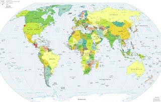
LEGEND for OVERVIEW: Size = My surety of area for quake.
Red Circle = Probable quake to STRONG quake.
Triangle = Very Strong/Stronger quake (Usually takes extra days).
Blue Circle, etc. = Uncertainty of symptom area for probable quake.

Places to watch.
For this day I had the least amount of symptoms
I think I have ever recorded. I felt lethargic all
day but had only 3 symptoms. Very odd.
Good luck to all.
For Monday, 10 July 2006.
----------------------------------------
Possibly Mount Jefferson (44.516N 122.394W)
or Gaston, Oregon (45.438 -123.298) (I always
have trouble pinpointing PNW - STRONG.)
----------------------------------------
1.6 2006/07/11 23:16:43 45.328 -121.698 5.5 22km(14 mi) E of Mount Hood Village, OR
1.6 2006/07/11 23:02:49 44.956 -123.305 0.0 4 km ( 2 mi) NNE of Dallas, OR
1.2 2006/07/11 22:46:34 45.332 -121.691 5.7 22 km ( 14 mi) SSW of Parkdale, OR
2.1 2006/07/11 22:38:01 45.326 -121.689 6.3 22 km ( 14 mi) SSW of Parkdale, OR
1.6 2006/07/11 22:37:46 45.329 -121.691 6.0 22 km ( 14 mi) SSW of Parkdale, OR
1.1 2006/07/11 22:35:24 45.335 -121.680 6.5 21 km ( 13 mi) SSW of Parkdale, OR
Nicaragua/Costa Rica
----------------------------------------
06/07/10 20:44:36 11.74N 86.89W 52.6 2.8ML Frente a Masachapa
06/07/10 15:52:18 10.65N 86.92W 15.0 2.0ML Oceano Pacífico de Nicaragua
06/07/10 15:17:44 10.77N 86.87W 7.5 3.4MC Frente a El Astillero
06/07/10 10:20:35 12.49N 85.89W 31.9 0.0 Nicaragua
Off the Coast of El Salvador
----------------------------------------
06/07/10 21:21:27 12.15N 89.02W 29.9 2.9ML Frente a El Salvador
Peace to all.

